The projects below show our restoration work in practice across settings as different as whitebait spawning habitat at the head of a harbour, purpose-built wetland refuges for a Nationally Critical fish, stabilising eroding loess slopes, and helping to manage a willow-choked braided river. Across all of them the work is the same at heart: restoring/improving habitat for a species or ecosystem and cultural values that depend on it, through hands-on design, field surveys, trials, and monitoring that show what actually works.
Īnaka ki Whakaraupō – Īnanga Spawning Habitat Design
A ki uta ki tai project with Te Hapū o Ngāti Wheke and the University of Canterbury to restore īnaka/īnanga spawning habitat and fish passage at the head of Whakaraupō – pairing Western science with mana whenua knowledge to put a mahinga kai taonga back on the right trajectory.
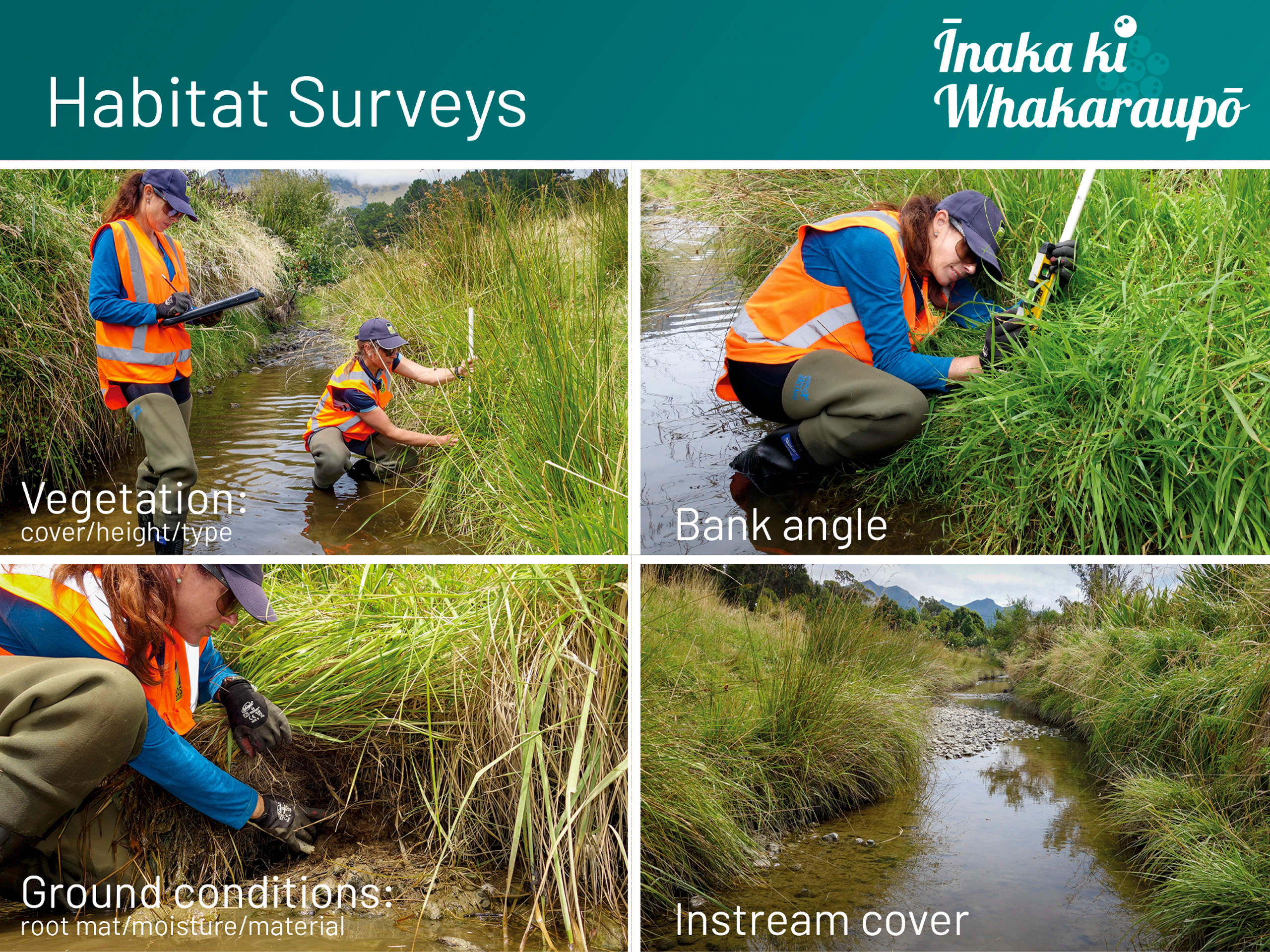
Īnaka ki Whakaraupō is a multi-year restoration project undertaken in partnership with Te Hapū o Ngāti Wheke – mana whenua of Whakaraupō – and the University of Canterbury Marine Ecology Research Group, with EOS Ecology providing the scientific and design lead. Set under the Head of Harbour Project (itself part of the wider Whaka-Ora Healthy Harbour Plan for Whakaraupō/Lyttelton Harbour), the work targets īnaka/whitebait, a mahinga kai taonga whose spawning success at the head of the harbour had declined to the point that egg counts across the focus catchments were running in the tens of hundreds rather than the tens of thousands that healthy populations produce. The project deliberately takes a ki uta ki tai (mountains-to-sea) approach, integrating Western science with the historical knowledge held by Ngāti Wheke to make sure restoration priorities align with both ecological and mana whenua aspirations.
Informed by University of Canterbury saltwater wedge surveys (the upper tidal reach where saltwater meets freshwater and īnaka characteristically spawn), we undertook spawning habitat suitability surveys, and spawning surveys (egg counts) at five inner-harbour waterway sites. From those surveys we identified three priority sites where targeted habitat improvement would deliver the largest gains. Alongside the fieldwork, EOS Ecology built a multifactor GIS-based prioritisation framework for fish passage barriers across the wider Whakaraupō catchment – a scoring system that weights mahinga kai value, waterway flow permanence, land protection status, land cover, and landowner engagement feasibility, so limited remediation effort can be directed where it will most clearly translate into improved access for īnaka/whitebait returning from the sea, and adult īnaka moving downstream into spawning reaches.
One of the priority sites, Allandale Stream, became the focus for detailed design drawings, prepared with Lucas Associates as landscape architects. Three remediation focus areas address different parts of this catchment. In the lower tidal reaches, mature riparian planting has improved terrestrial values, but the vertical eroding banks are not suitable īnaka spawning; the design re-contours and batters the banks, uses coir logs to help build out the toe of eroded banks and sources vegetation suitable for inanga spawning. Further upstream an existing concrete-and-boulder weir adjacent to farm buildings attenuates sediment usefully, but blocks adult īnaka from moving upstream into to deeper pools, so the design remediates the fish passage barrier without losing the sediment-trapping function. Higher in the valley, the design for a 3.5–4 m eroded channel provides a way to reconnect the narrow channel with a wider flood plain whilst at the same time helping to manage bank erosion and promote water treatment. Together, the package gives Ngāti Wheke a buildable, science-supported pathway for restoring īnaka to one of the catchments that historically supported them, and the prioritisation framework gives the wider Head of Harbour Project a way to extend the same logic across the other catchments around Whakaraupō.

Papatahora Stream Restoration
Aquatic ecology across two phases of consenting for a culturally significant small stream flowing through Ngāti Moki Marae – part of the mana whenua-led Whakaora Te Waikēkēwai project restoring waterways across the Taumutu coastal margin of Te Waihora/Lake Ellesmere.
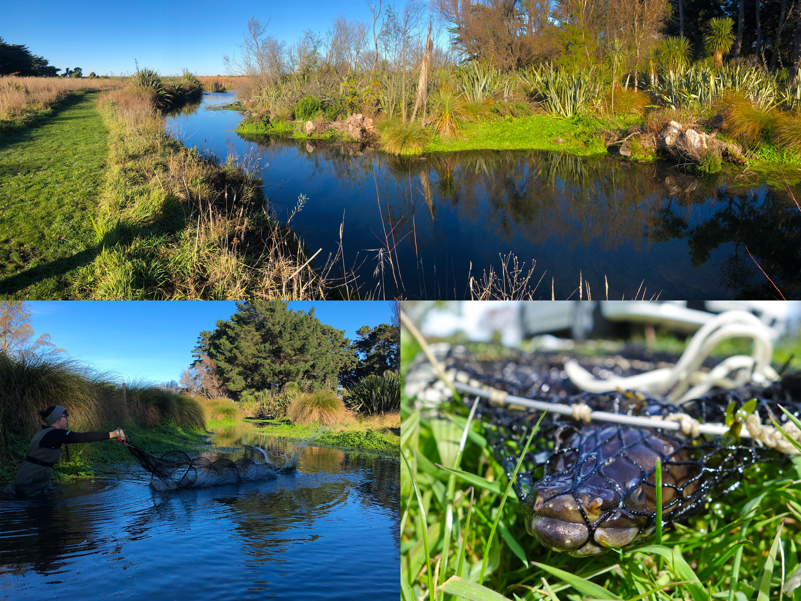
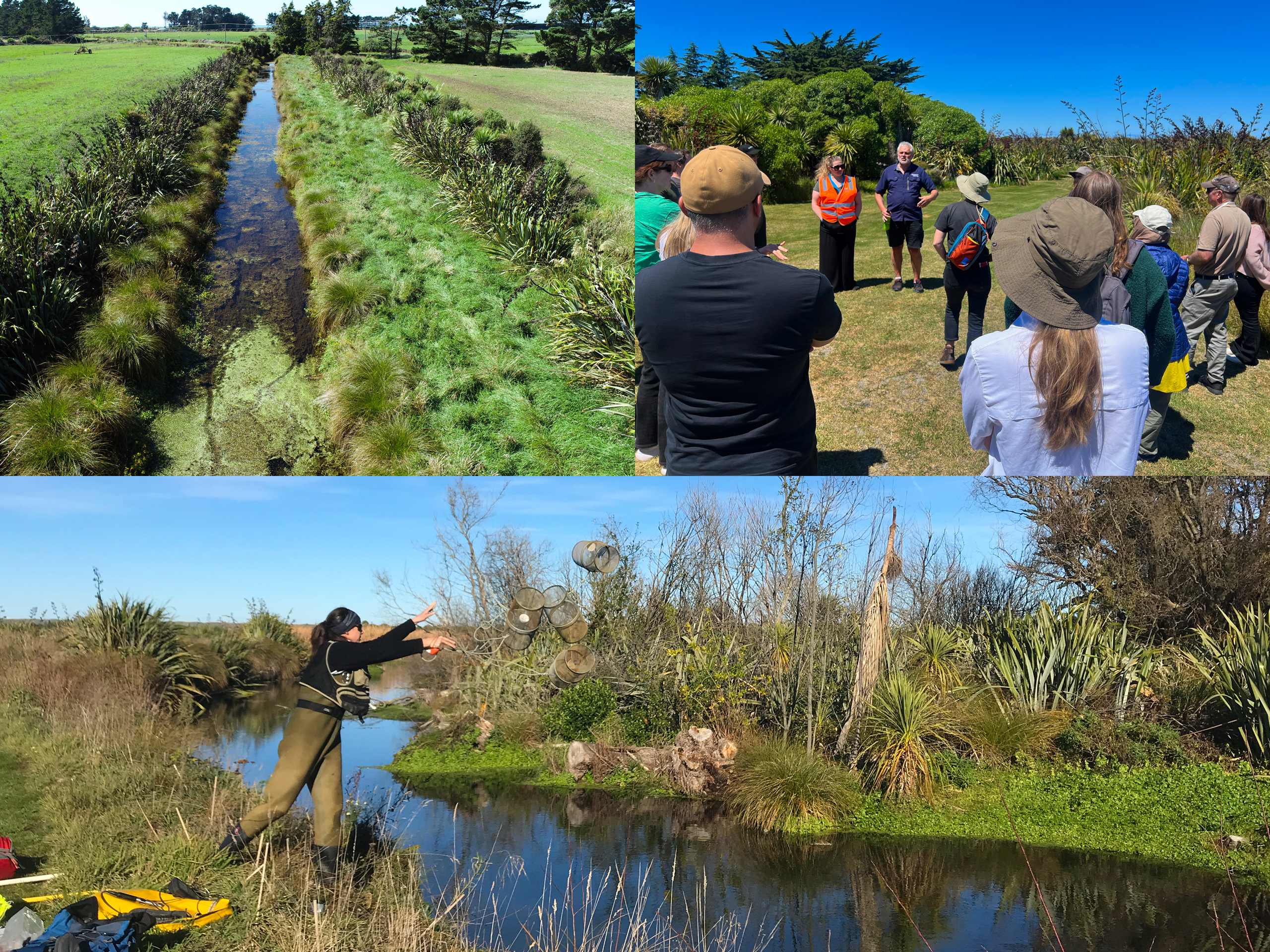
Papatahora is a small stream on the south-eastern side of Te Waihora/Lake Ellesmere at Taumutu, flowing through the grounds of Ngāti Moki Marae before joining Te Waikēkēwai, which winds through Te Repo Orariki/Taumutu Wetlands and discharges into Te Waihora. The stream is the focus of restoration under Whakaora Te Waikēkēwai – a mana whenua-led project within the broader Whakaora Te Waihora programme to enhance mahinga kai habitat, improve water quality, and increase indigenous biodiversity. EOS Ecology was commissioned by Te Taumutu Rūnanga and Environment Canterbury to deliver the ecological inputs for two phases of resource consenting: an initial AEE in 2020 for sediment removal from a 90 m section downstream of Pohau Road, and a 2024 update extending the assessment 950 m upstream to support a wider set of proposed restoration measures.
The 2020 work paired in-stream and riparian habitat assessments with kick-net macroinvertebrate sampling and a full fish-survey programme (Gee’s minnow traps, fyke nets, and electrofishing) across Papatahora and its downstream receiving environment in Te Waikēkēwai. The 2024 update added eDNA sampling at two upstream sites as a time- and cost-effective way to expand the baseline.
Both AEEs were delivered to tight consent timeframes, with joint pre-survey site visits with the rūnanga and regional council to align expectations from the start. The AEEs provided recommended mitigation measures to help reduce effects of the construction phase, with the proposed works already designed to improve ecological values long term. We also helped with writing consent conditions to ensure practical onsite applications of the in-channel works.
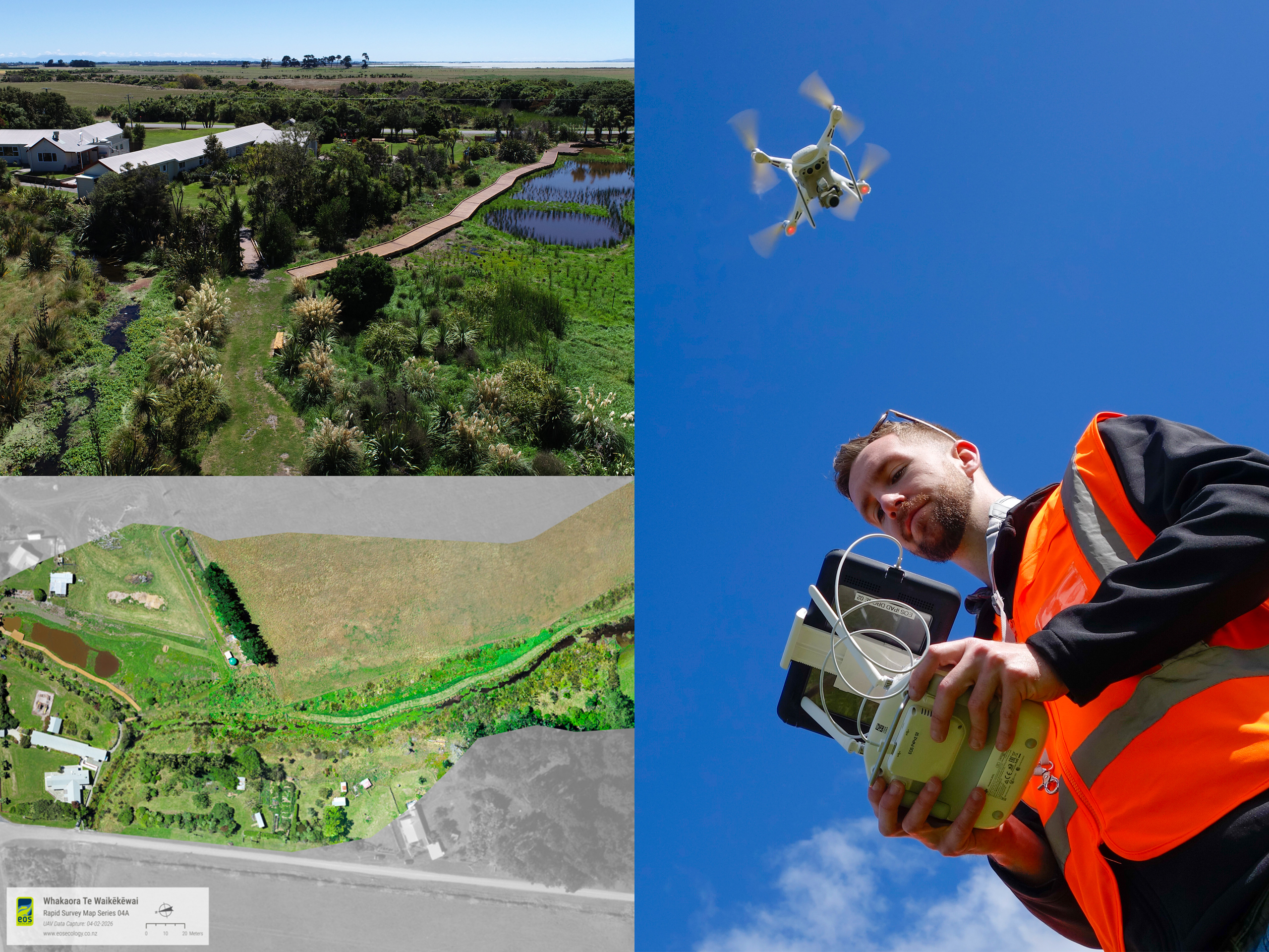
Beyond the formal AEEs, the work extended into close collaboration with planners, contractors, and the Whakaora Te Waihora team on practical sediment removal methodology, how ecological design can be embedded into the works themselves to maximise habitat outcomes, and options for long-term sediment management. EOS Ecology also undertook drone flights to capture video and photos of the restored waterway and wetland following project completion, along with high-resolution georeferenced orthomosaic maps that support project reporting and help guide future catchment-based mahi.
Kōwaro/Canterbury Mudfish Habitat Restoration & Management
Securing the future of the Nationally Critical kōwaro/Canterbury mudfish through new and restored habitat, drone-tracked plant establishment, and the DOC-approved transfer plan that puts founder populations back into suitable refugia across Canterbury.
Kōwaro/Canterbury mudfish (Neochanna burrowsius) is one of just four Aotearoa New Zealand freshwater fish species classified as ‘Threatened – Nationally Critical’ (with the qualifier ‘conservation dependent’) – the highest threat status the country gives an extant freshwater fish. Its distribution is limited to 16 Mid and South Canterbury catchments, fragmented across an agricultural landscape. EOS Ecology was engaged by Environment Canterbury (ECan) to support two large-scale flow management programmes, both delivered under the Canterbury Water Management Strategy and aligned with Action 4.3 of the NZ Mudfish Recovery Plan. The work was undertaken in close collaboration with DOC, and built on former work undertaken by kōwaro/Canterbury mudfish specialist consultancy Ichthyo-niche.
On the ground, EOS Ecology has designed and overseen construction of new kōwaro habitat at two Mid Canterbury sites, which provide the perfect conditions for kōwaro to breed whilst protecting them from fish predators and competitors, and implemented monitoring of habitat conditions to identify when conditions become suitable for transfer of this taonga species, so as to avoid mortality due to early release.
On the regulatory side, we authored the DOC-approved kōwaro Transfer Plan for the release sites, alongside site-specific Management Plans for each release site – each plan setting out a 14-criterion habitat-suitability checklist that has to be met before any fish are moved. As the DOC-approved kōwaro specialist Project Ecologist for the related Waikirikiri/Selwyn River Near River Recharge (SRNRR) Project, we have also been responsible for reviewing operational plans for the water recharge programme to ensure it doesn’t cause adverse effects to kōwaro populations in the catchment.
Our kōwaro transfer protocols are deliberately conservative, with a stocking rate that is a third of the maximum recorded mudfish density from their source populations, fish released across multiple seasons, transfers staged through autumn into early winter so fish are settled in time for late-winter/early-spring spawning, and an adaptive-management feedback loop that lets the programme pause or accelerate based on monitoring results. The multiphase programme has set everything in place to facilitate the successful transfer and long-term management of a species that is dependent on conservation efforts such as this in order to survive.

Selwyn Water Race Kōwaro/Canterbury Mudfish Habitat
Site-specific habitat protection and restoration for one of the few remaining wild kōwaro/Canterbury mudfish populations currently sheltering in a section of the Selwyn District Council's water race scheme.
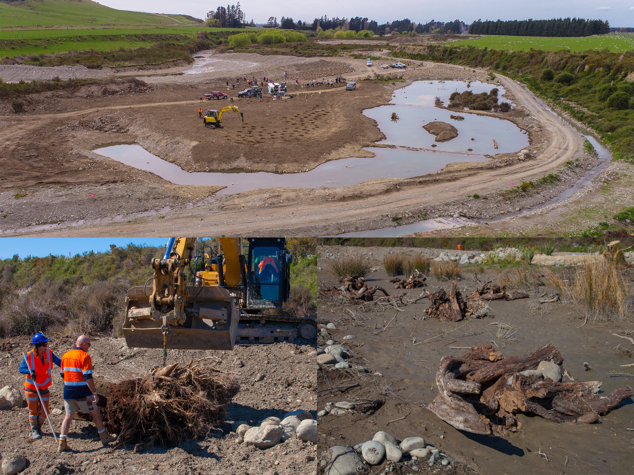
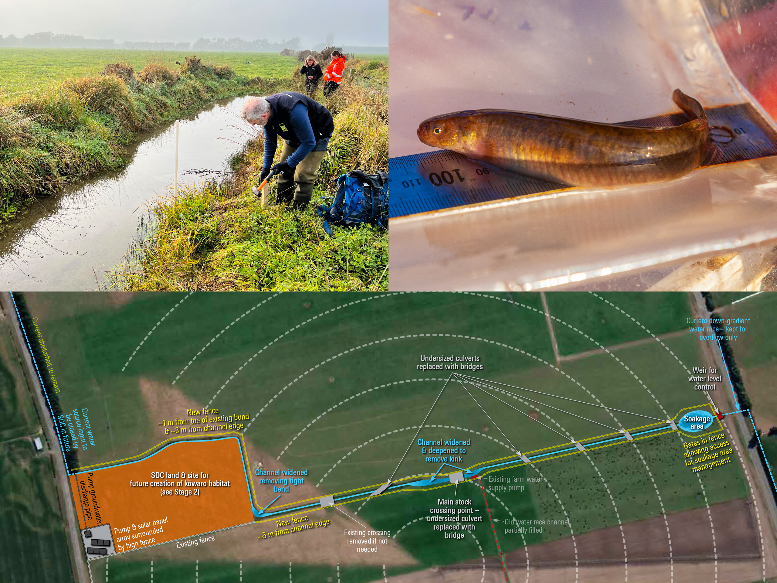
A terminal section of Selwyn District Council’s (SDC) water race scheme supports one of the few remaining wild populations of kōwaro/Canterbury mudfish, one of just four Aotearoa New Zealand freshwater fish classified as ‘Threatened – Nationally Critical’. The site sits at the intersection of competing management drivers: DOC is responsible for ensuring the longevity of the remnant population; SDC manages the water race for stock-water delivery and is looking to close parts of the wider network; the network itself is subject to short-notice closures as a result of a flow-sensitive intake site; Sicon (as SDC’s water-race flow contractor) needs to manage the water race for flow, including macrophyte and sediment removal; ECan is responsible for ensuring consents are applied for and managed effectively; and the landowner (a Fonterra farm) who is amenable to retaining and enhancing this section of terminal water race to protect the population. EOS Ecology was engaged by DOC to provide independent facilitation and expert advice to come up with a design and site-specific management plan that can hold all these interests together while securing the population’s future.
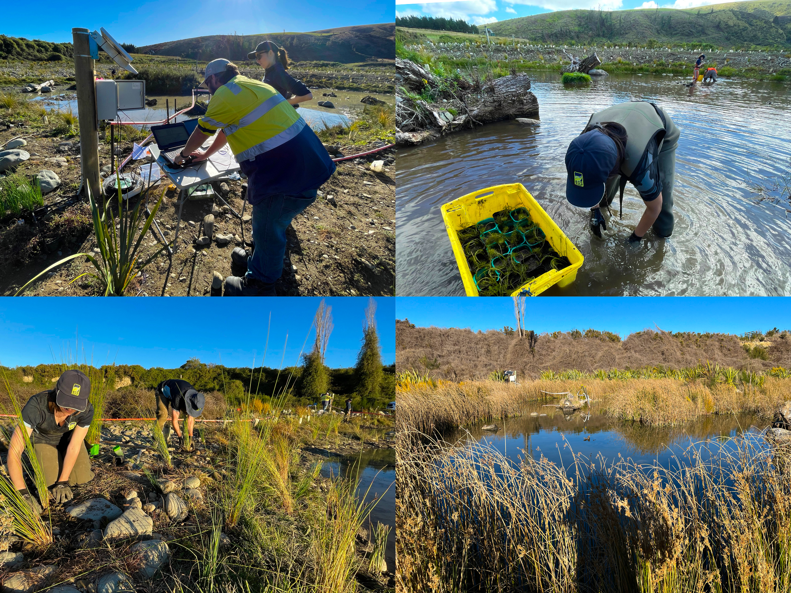
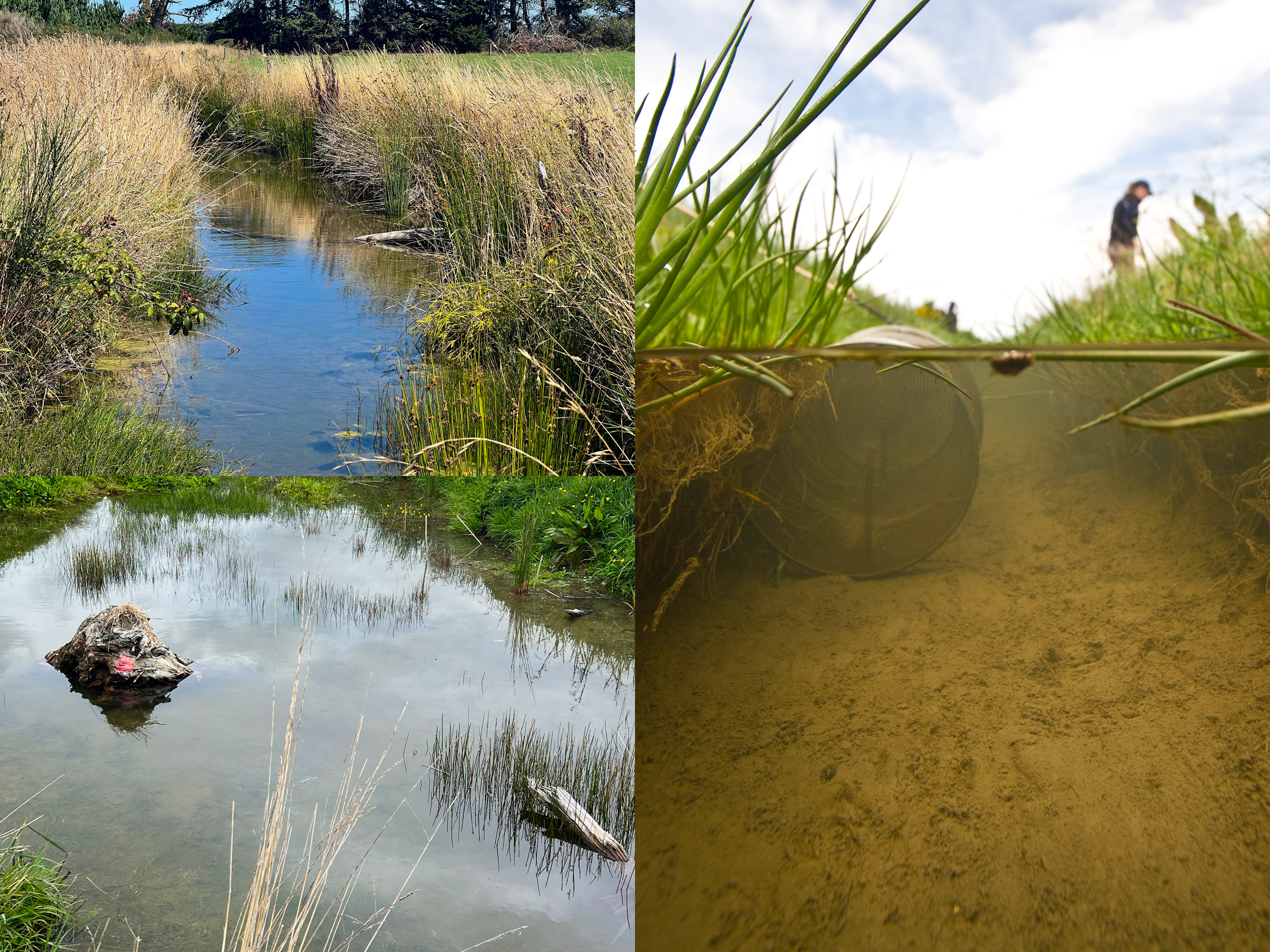
Our initial three-tier advice memo recommended separating this reach from the wider water-race scheme so it could be managed for kōwaro specifically, and that recommendation crystallised into a Management Plan recognised by all project partners. The plan addresses a core ecological tension: kōwaro need exactly the conditions that standard rural stream and water-race management actively removes. They prefer still or very slow-flowing ‘swampy’ habitats with deep pools, soft substrate, and extensive aquatic vegetation (which they use both as food and as spawning substrate – eggs are spread widely through the vegetation, and the fish delay spawning when it is absent), and they need to be kept apart from predators such as trout. The plan proposes a two-stage transition: Stage 1 improves the existing channel habitat, secures an independent flow source via a solar-powered groundwater pump and isolates the site from the wider scheme, so the kōwaro habitat no longer depends on the wider water race network for flow. Stage 2 then offsets the loss of upstream and downstream habitat by creating 2.2 ha of new pond and stream habitat on adjacent SDC land, including deeper lined ponds as drought refugia.
EOS Ecology then delivered the ecological design that put the first part of the plan into practice. We have designed channel improvements, new pivot irrigator crossings, and planting plans for the existing channel prior to flow discharge into a new terminal soakage pit. We have overseen fish removal work during pivot-crossing construction, where undersized polythene-pipe culverts were replaced by a single span concrete bridge crossing per pivot – opening up channel flow and reducing blockage events that had previously inundated adjacent paddocks. More recent flow-gauging work is informing the design of the long-term groundwater supply that Stage 2 depends on. Together, these incremental design steps are securing the future of a critically important kōwaro population.

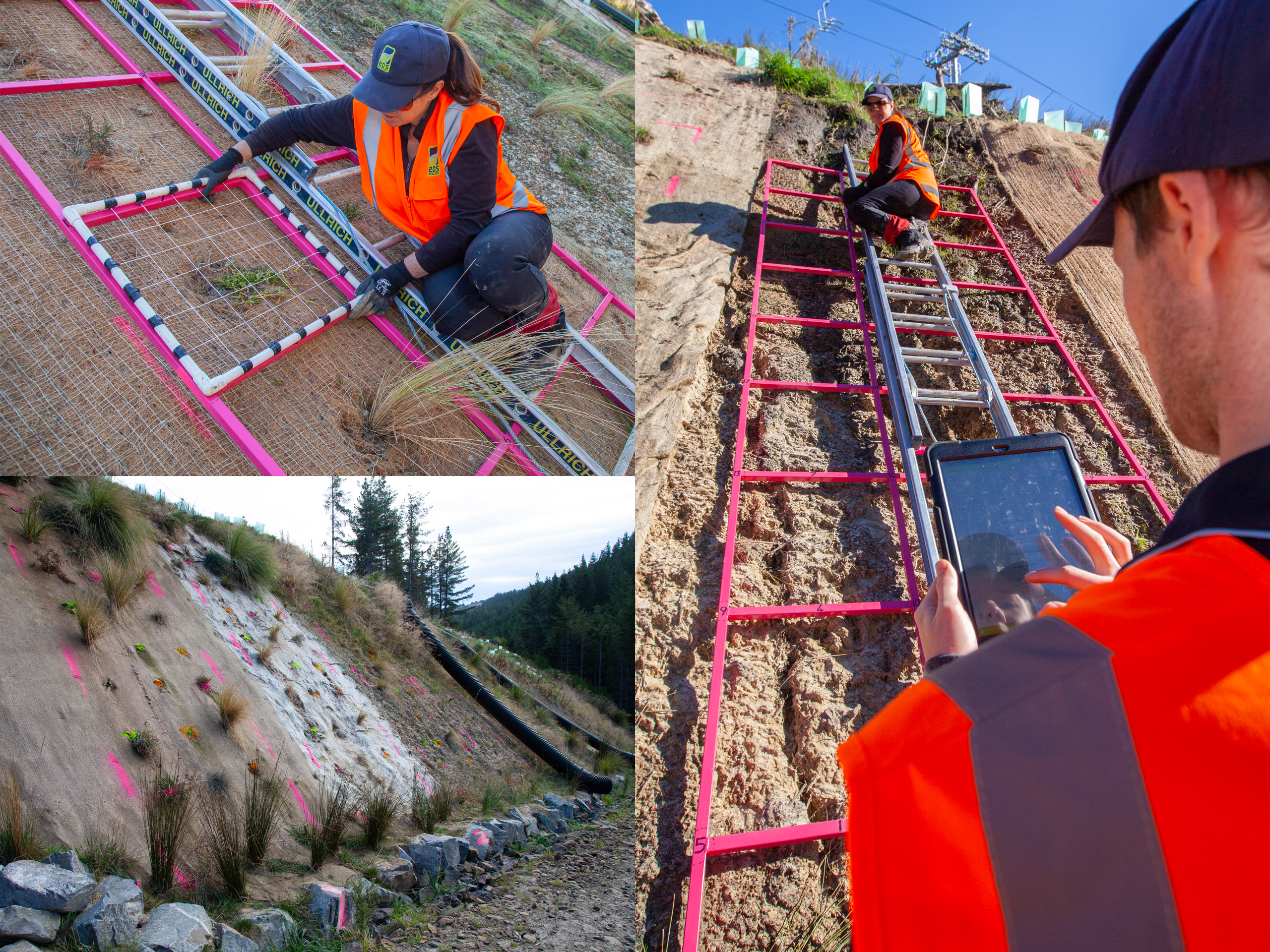
Port Hills Erosion Control Trials
A replicated field trial of five commonly-used erosion-control treatments on Port Hills loess, designed and run with the Cashmere Stream Working Group – generating the quantitative evidence base that fed directly into updates to Canterbury's Erosion and Sediment Control Guidelines and provides needed guidance to contractors undertaking hill-based developments.
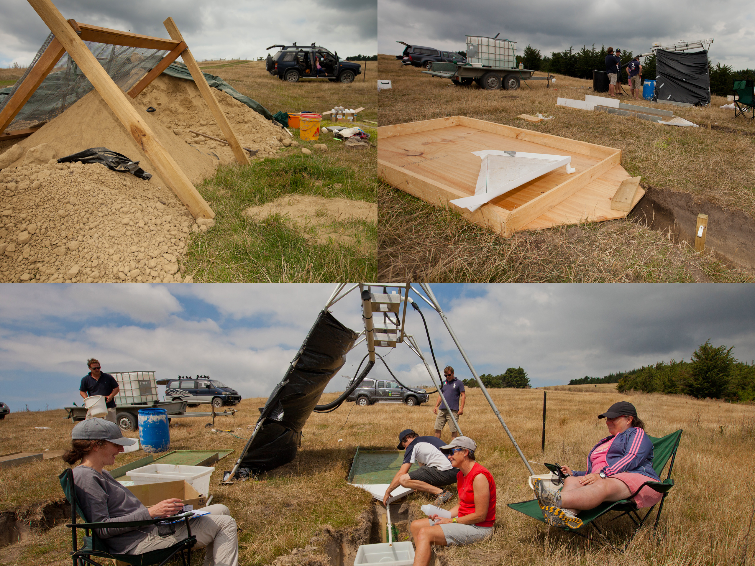
The dispersive loess soils on the lower slopes of Christchurch’s Port Hills are highly erodible the moment they are exposed, and the post-earthquake surge in construction activity on the hills had placed pressure on the waterways draining them, with the loess clay-sized particles highly dispersive and prone to staying in suspension, leading to prolonged ecological effects in receiving environments. The Cashmere Stream Working Group of the Christchurch–West Melton Zone Committee commissioned EOS Ecology, on behalf of Environment Canterbury, to design and run a replicated field study of the erosion-control products being used on Port Hills construction sites to determine which interventions are most effective at keeping loess in its place. This was so contractors, councils, and consent authorities had real quantitative evidence, rather than supplier claims, to go on, and the findings could feed directly into updates to Canterbury’s Erosion and Sediment Control (ESC) Guidelines and to construction-phase consent conditions.
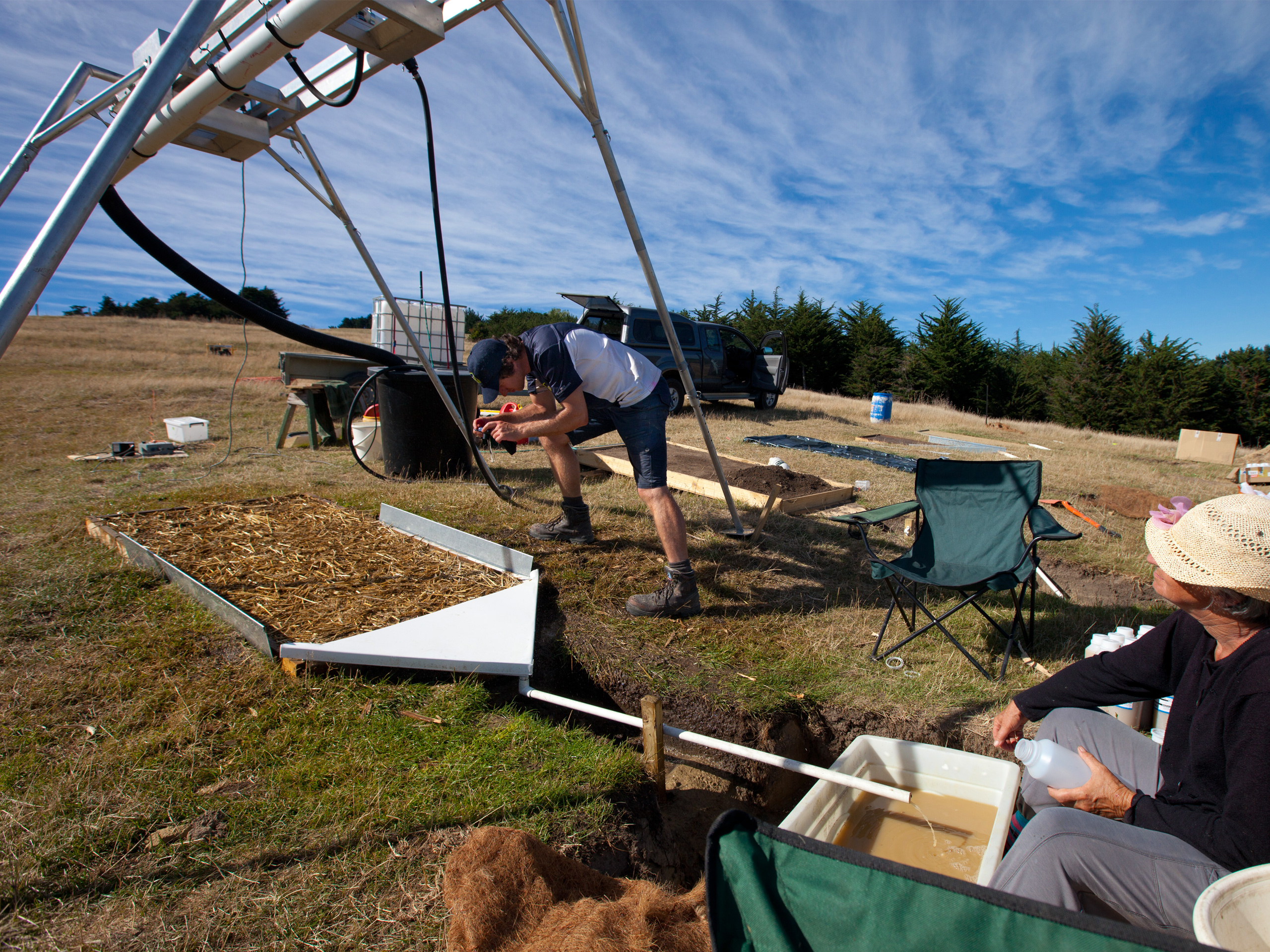
Across three weekends in February 2016, with volunteer community help organised by the Working Group, we tested five erosion-control treatments – topsoiling, straw mulch, coconut fibre blanket, and two hydraulically applied soil stabilisers (WRD-L and Vital Bon-Matt Stonewall) – against bare loess subsoil controls. Each treatment was applied in triplicate over loess subsoil sourced from a nearby construction site, hand-compacted into 2 m × 1 m soil boxes set at an 11 degree slope. A programmable rainfall simulator delivered 29 mm/hr for one hour while one-litre sediment samples were collected at five-minute intervals and returned to the laboratory for analysis. The results provided clear findings of the efficacy of the tested erosion control measures, with straw mulch achieving a 95% reduction, coconut fibre blanket 94%, Vital Bon-Matt Stonewall 90%, basic topsoiling 86% and WRD-L a 48% reduction in suspended sediment loads compared to the control plots.
The trial carried several messages that have shaped Port Hills construction practice since. Even slopes protected with these products still released sediment at concentrations above generally consented limits – meaning a ‘treatment train’ of erosion control plus downstream sediment management is still essential on any substantial earthworks site. Hydraulically applied stabilisers depend on proper 100% coverage and timely reapplication if they degrade; every product has strengths and weaknesses; every newly exposed loess surface needs cover applied immediately; and the most reliable long-term solution remains rapid establishment of vegetative cover assisted by topsoil. EOS Ecology translated the trial results into a companion memo recommending specific updates to Canterbury’s ESC Guidelines and to construction-phase consent conditions, including loess-specific guidance on soil horizons, dispersive-soil recognition and management, and the appropriate matching of short- and long-term erosion-control measures to construction staging. The 2016 study also laid the empirical foundation that EOS Ecology later built on in the Cut Slope Erosion trial at the Christchurch Adventure Park.
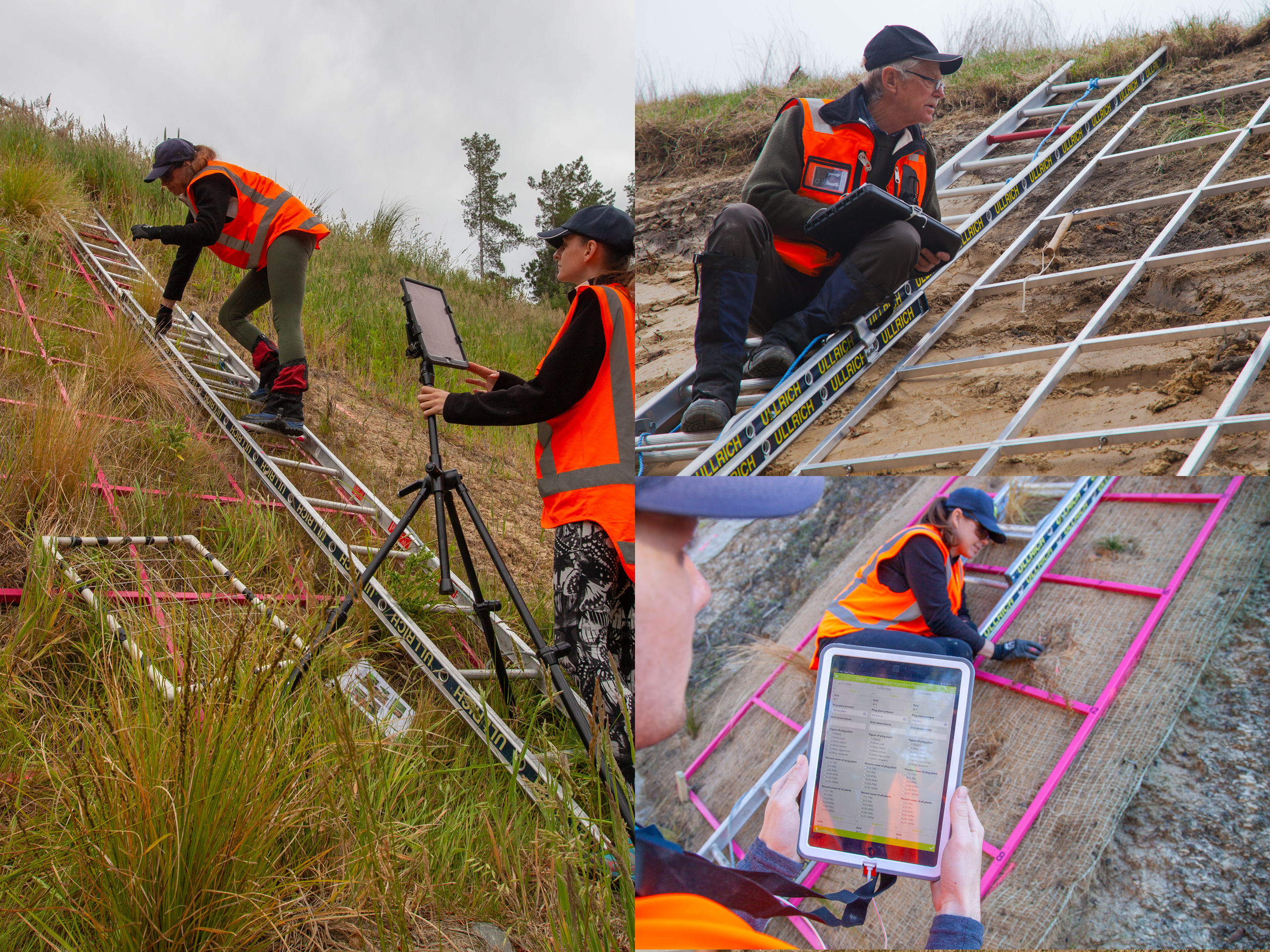
Cut-Slope Erosion Control Research
A multi-year replicated field trial testing low-cost, soft-engineering solutions to reduce sediment runoff from the bare loess cut faces along Port Hills and Banks Peninsula roads – the first such study to test erosion-control products and native plantings against proper experimental controls.
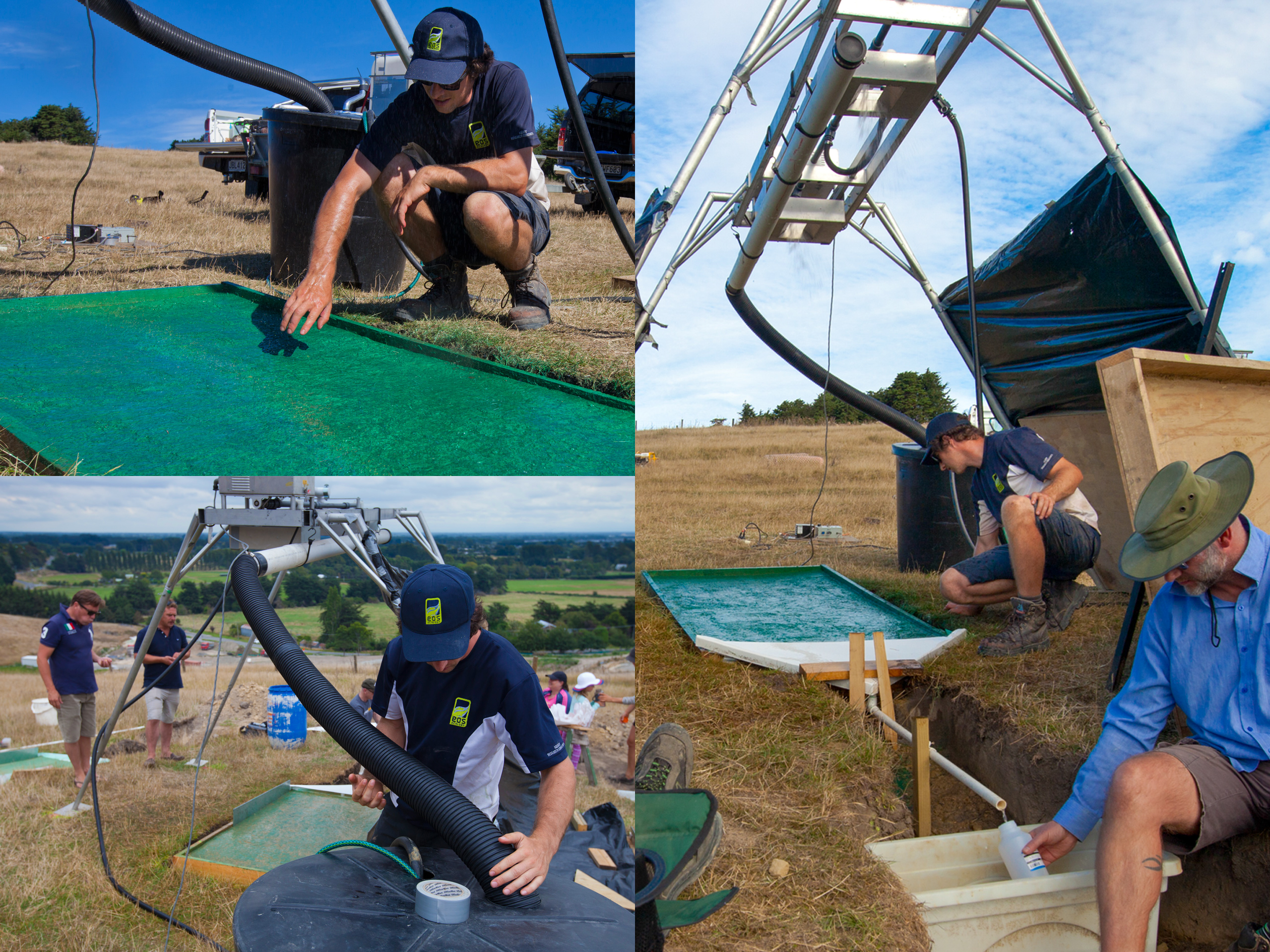
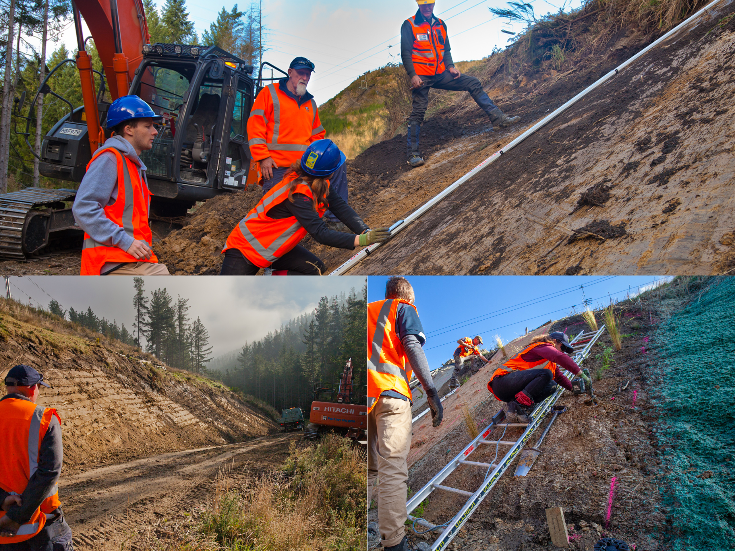
The loess soils on the lower slopes of Christchurch’s Port Hills and Banks Peninsula are silt-sized, chemically dispersive when wet, and prone to severe erosion the moment vegetation and topsoil are removed, generating sheet-wash and rill erosion at the surface, slips and tunnel gullies at depth, and a fine sediment load that is then very difficult to remove from water once it is in suspension. Exposed roadside cuttings are an obvious source, and with limited room in the narrow road corridors around the harbour for downstream treatment systems, the onus has to fall on reducing sediment runoff at the cut face itself. As part of the Whaka-Ora Healthy Harbour initiative, and with support from the Banks Peninsula Zone Committee, Christchurch City Council and Environment Canterbury commissioned EOS Ecology to design and implement a three-year replicated field study testing ‘soft’ erosion-control measures on loess cut slopes: the first such trial after years of largely anecdotal supplier-led product testing.
After a pilot study summarising existing knowledge of erosion around Whakaraupō/Lyttelton Harbour and shortlisting a number of sites suitable for undertaking a multi-year field trial, EOS Ecology partnered with Manaaki Whenua Landcare Research (now Bioeconomy Science Institute) to develop the experimental design and with Fulton Hogan to ready a south-facing cut-loess site within the Christchurch Adventure Park. To run the replicate treatment experiment design, the site underwent initial setup by Fulton Hogan in mid 2019, including rebattering and scraping the face to expose fresh loess subsoil, constructing a stable rock toe at the base, a bidim-lined rock channel water table at the toe, and installing diversion flumes to redirect upslope water away from the cut face. Five erosion-control products were then applied by product suppliers in a randomised block design with three replicates each, alongside three untreated control plots. Six native plant species were plug-planted into each treatment plot, four replicates each. EOS Ecology then implemented a multi-tier monitoring programme that measured erosion features, product condition and cover, vegetation cover and plug-plant vigour in 24 replicate grids within each of the treatment and control plots, over a 30 month (2.5 year) period.
By the end of monitoring a clear hierarchy had emerged, with the best performing product being a sprayed treatment with a stable matrix and nutrient supplement combined with cover-crop seed mix – the second was a thick rolled product. Among the plants, silver tussock (Poa cita) was the standout performer across all cover and vigour attributes, with Banks Peninsula fescue (Festuca actae) the next best. The New Zealand ice plant grew vigorously where protected, but proved unusable in unprotected settings after wildlife cameras caught possums systematically grazing it – the trial had to substitute Carex comans mid-study. The core conclusion: managing a loess cut slope effectively needs both a product and the right plant community – a product that can provide both immediate erosion control while the plants establish, but also supports plant establishment and growth in the long-term prior to decay of the applied product; and plants that can grow in the challenging conditions of loess subsoils. Our findings also highlighted the importance of other features inherent in effectively stabilising cut slopes – a stable rock toe so that banks are not accidentally over-steepened by mechanical removal of sediment, and a means to keep concentrated overland water flow off the cut face. The results have been written up in a technical Year 3 Monitoring Report and a separately published summary document, so the findings can be applied not just by councils and contractors on roadside cuttings, but by private landowners around the Peninsula with their own cut-bank challenges.
Hakataramea River Willow Pest Management
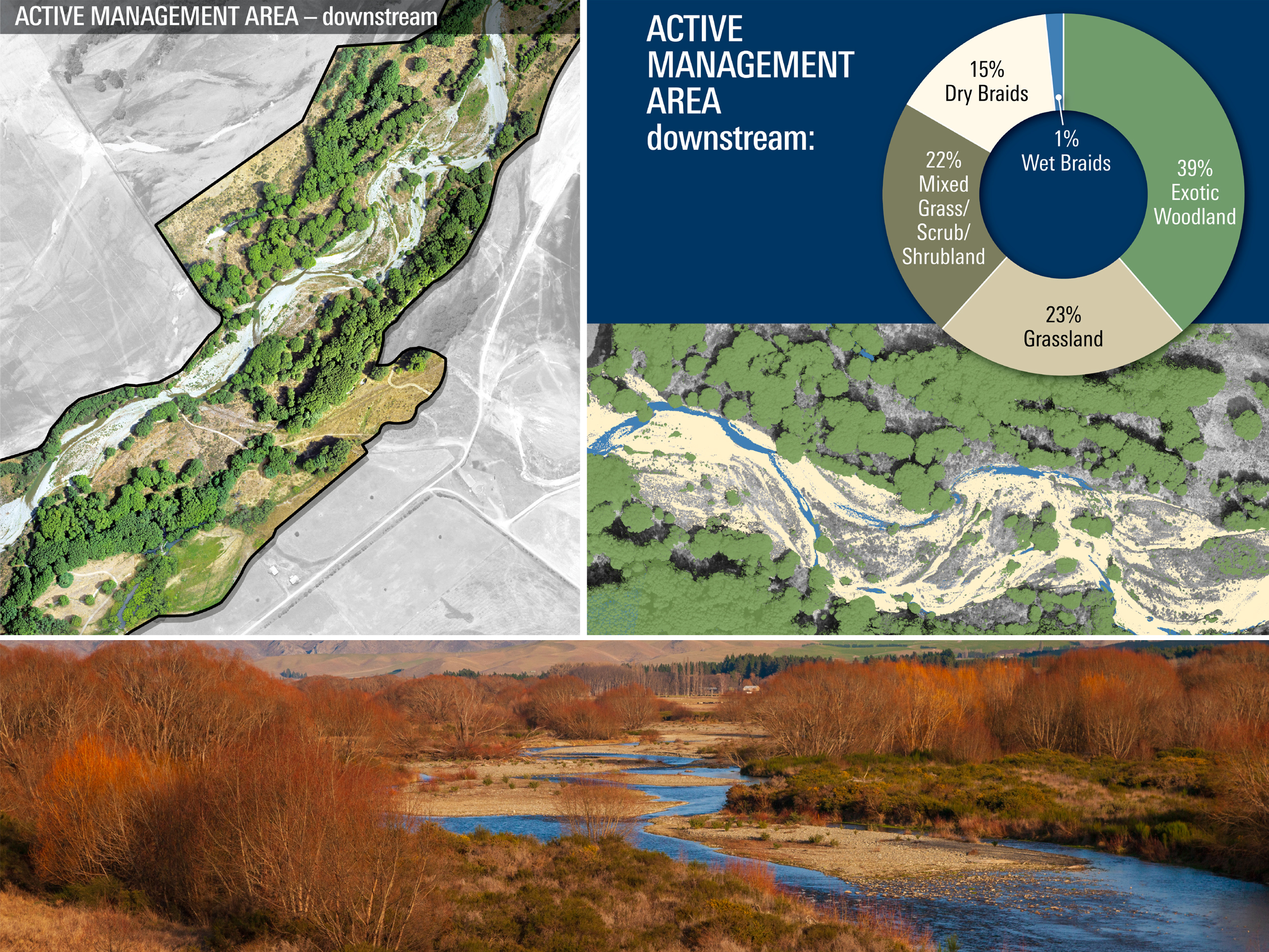
A sub-centimetre-resolution UAV survey and image-classification baseline for the Hakataramea Sustainability Collective's braided-river willow management programme – a repeatable, scientifically defensible record against which future control work can be quantitatively measured.
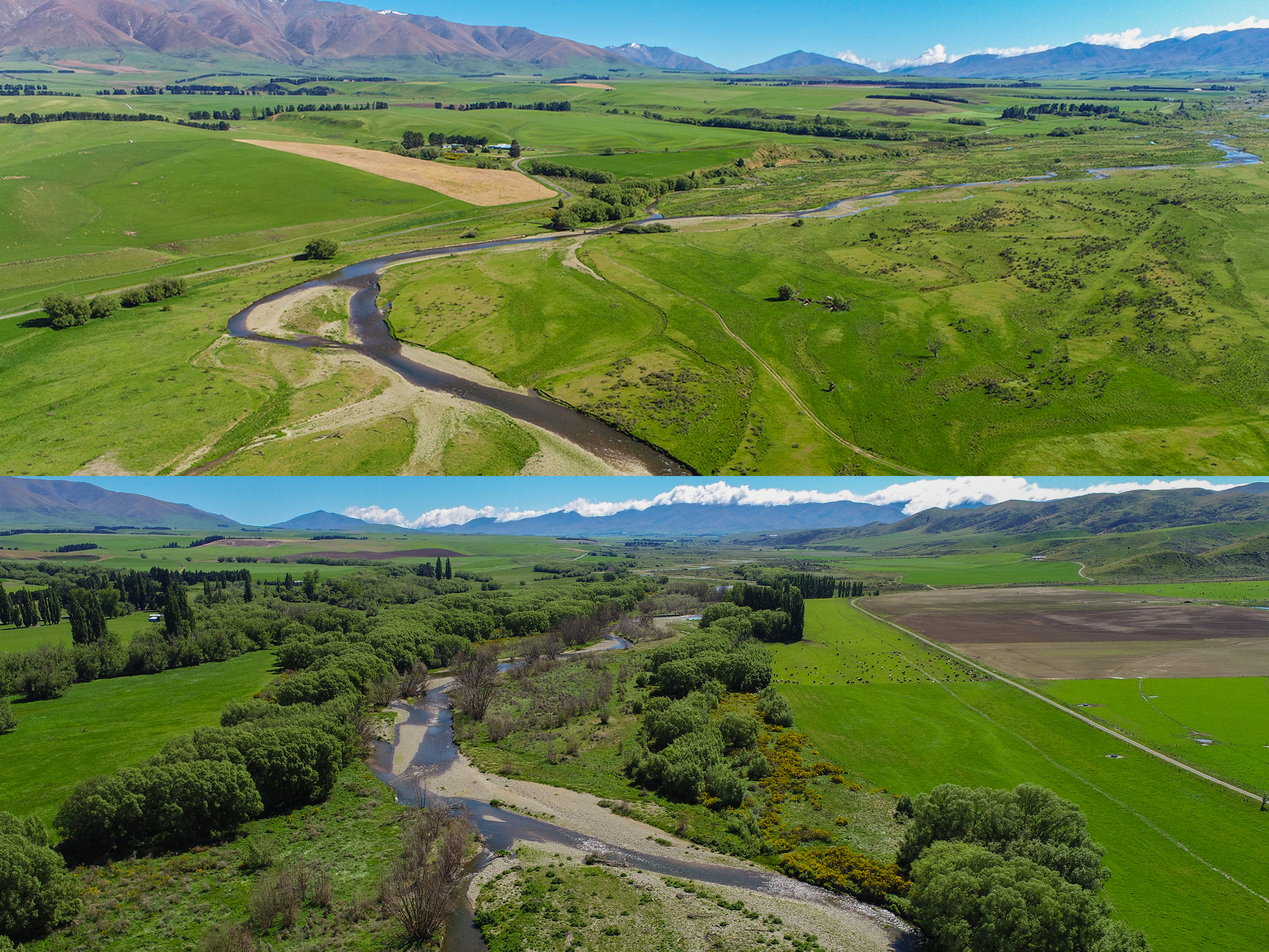
Braided rivers are one of Aotearoa New Zealand’s distinctive river systems and a hotspot for indigenous biodiversity, but they’re also one of the country’s most rapidly degrading habitats, with exotic willow species progressively altering river morphology, outcompeting native vegetation, and crowding out the open shingle and braid habitat that braided-river plants and animals depend on. The Hakataramea River, a braided tributary of the Waitaki in inland South Canterbury, has extensive willow cover in its lower reaches. The Hakataramea Sustainability Collective (HSC) was running an aerial willow-control programme, but lacked the quantitative baseline needed to demonstrate how effective the work was. HSC commissioned EOS Ecology to build that baseline using a precise, scientifically defensible, and repeatable methodology – one against which the success of the willow control could be measured over time and which could carry across the wider catchment as their management programme extended.
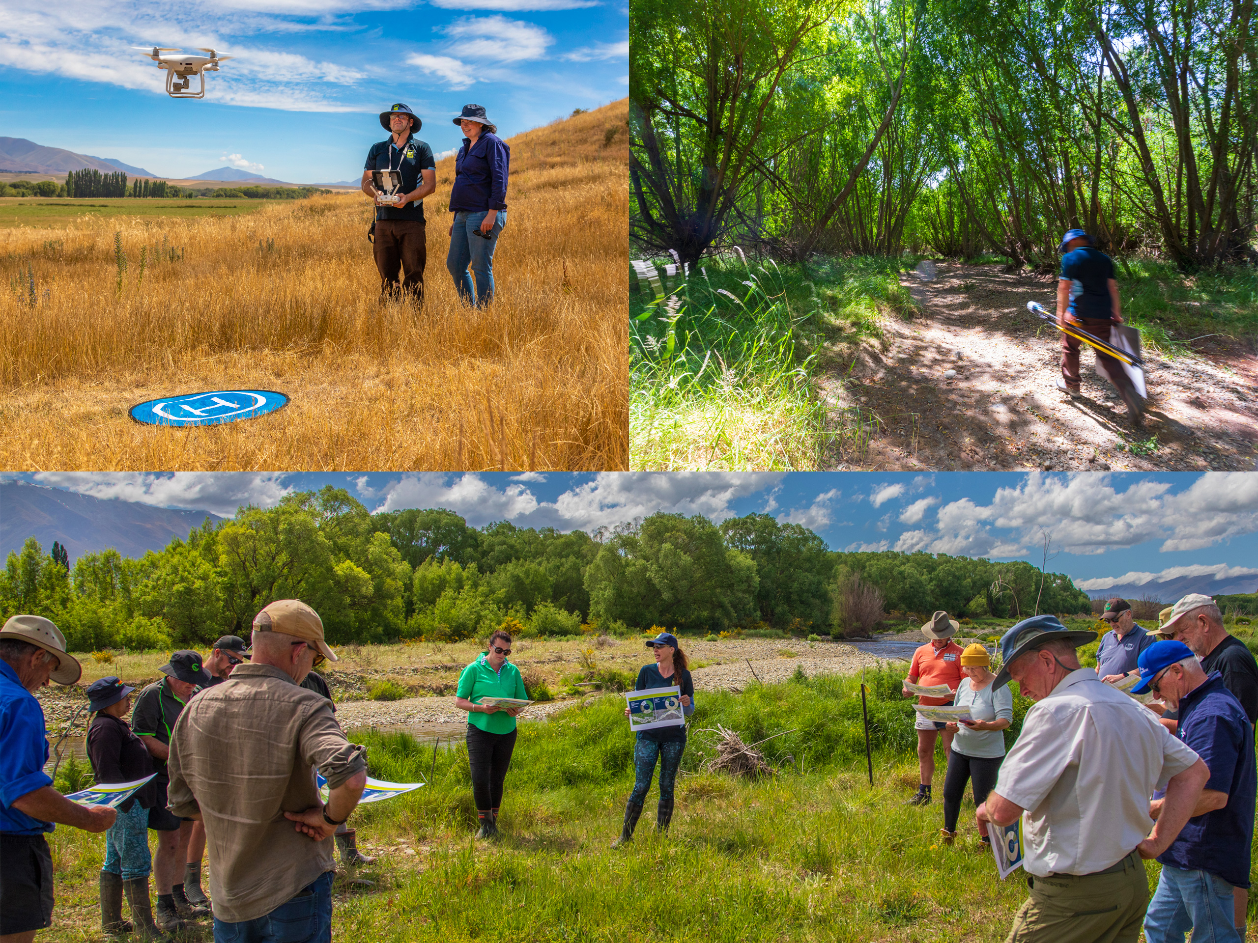
Across three days in January 2024, deliberately timed just four days before HSC’s scheduled aerial willow spray, we flew the 265 ha project management area, capturing 5,876 images at 2.7 cm/pixel resolution, significantly finer than the publicly available aerial imagery for the catchment. Twenty-two ground control points gave the resulting orthomosaic survey-grade positional accuracy, and a supervised image classification in ArcGIS divided the area into seven land-cover classes. We treated the area as a quasi-experimental study, splitting it into a 120 ha Downstream Active Management Area (where HSC’s willow control is being concentrated) and a 145 ha Upstream Control Area largely clear of willows and managed under a different approach – the downstream area carried 38.7% exotic woodland cover (46.6 ha of willows) against 6.4% in the upstream control area.
The orthomosaic and classification together provide HSC with a precise, georeferenced baseline that any future UAV survey can be quantitatively compared against – change detection rather than qualitative impression. As HSC extends its willow management programme into other parts of the catchment, the same methodology can be applied at low marginal cost, and because the framework is repeatable, HSC is now positioned to demonstrate efficacy to funders and partners using comparable hectare-and-percentage numbers across years, rather than narrative reports. The methodology itself is broadly transferable – high-resolution UAV mapping paired with supervised image classification has direct application to wetlands, salt marshes, river riparian zones, and any other context where land-cover change needs to be quantified at sub-metre precision over hectare-scale areas. EOS Ecology has the end-to-end capability that spans CAA-compliant data acquisition, geospatial processing, and the science interpretation that turns the imagery into management-relevant decisions.