The projects below show our catchment work in practice, at scales from a single small lake catchment to a national map series spanning eight regions and 3.7 million hectares, and in settings from lowland drainage districts and a foothill valley to a city’s largely piped urban streams. Across all of them the task is the same: draw together information from many sources into a clear picture of how a catchment works, and a practical, co-designed plan for acting on it. It’s work built to be carried forward by the councils, rūnanga, landowners and community groups who live and work in these catchments.
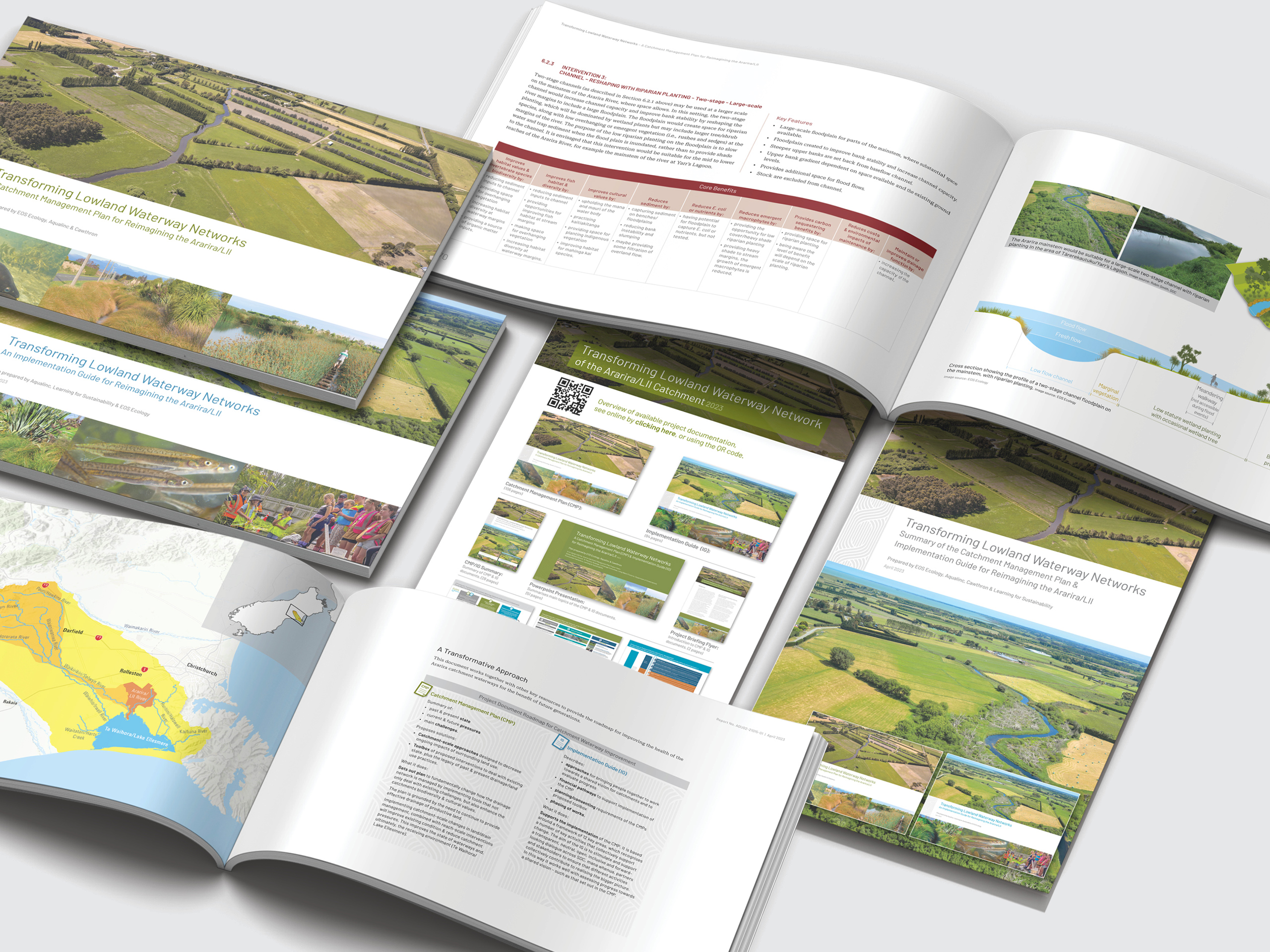
Ararira/LII Catchment Management Plan & Implementation Guide
A co-designed catchment plan for the Ararira/LII drainage district that fundamentally rethinks a lowland drainage network as an ecological and cultural system – the pilot that proved the Selwyn District catchment-planning model.
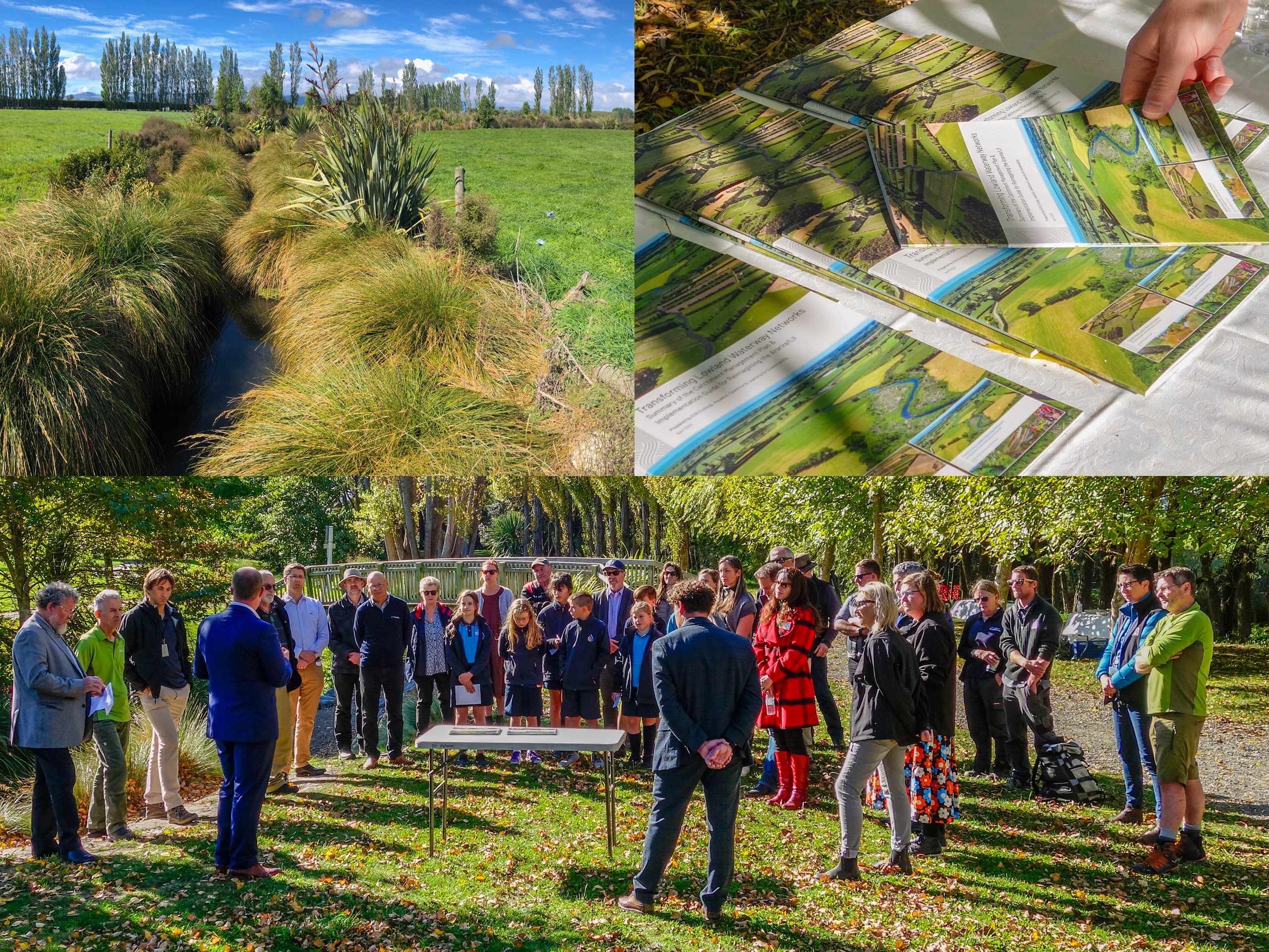
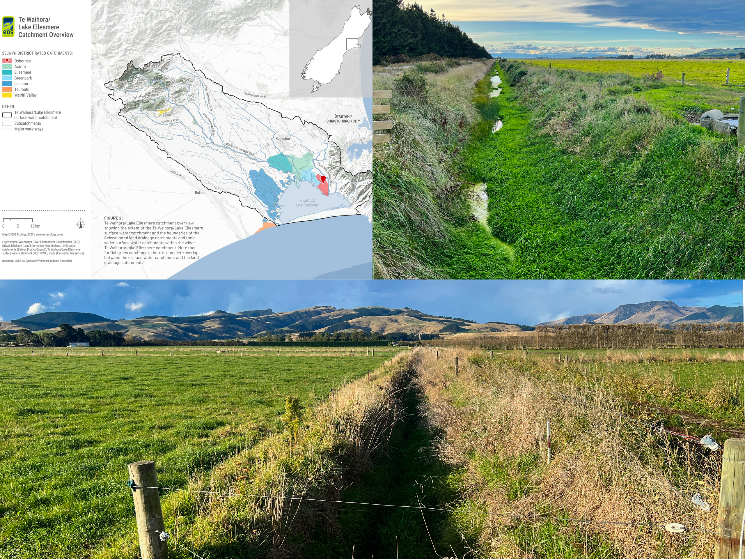
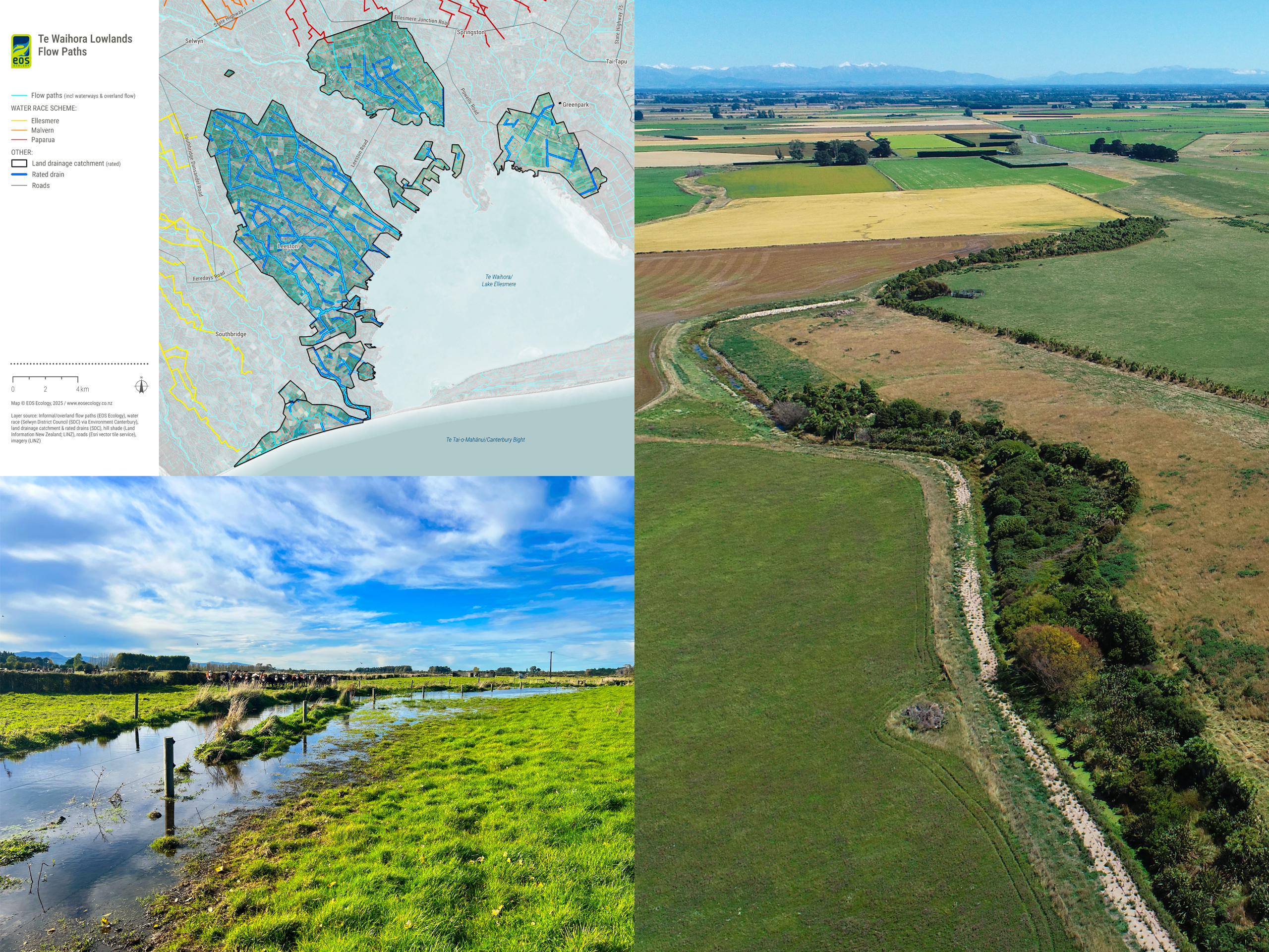
In October 2020, the DOC–Fonterra Living Water Partnership signed an MOU with Selwyn District Council (SDC) and Te Taumutu Rūnanga to develop a Catchment Management Plan (CMP) and Implementation Guide (IG) for the Ararira/LII River drainage district – the second-largest contributor of water to Te Waihora/Lake Ellesmere, one of Aotearoa New Zealand’s most degraded coastal lakes. EOS Ecology, working alongside Aqualinc Research (programme management and hydrology) and Cawthron Institute, was engaged to deliver the work in close co-design with SDC, the LII Drainage Committee, Te Taumutu Rūnanga, Living Water (Department of Conservation & Fonterra), Environment Canterbury and Learning for Sustainability. The MOU set the bar high: to fundamentally change how waterways were valued and managed by incorporating ecological and cultural principles into the design, while still recognising drainage as a key value.
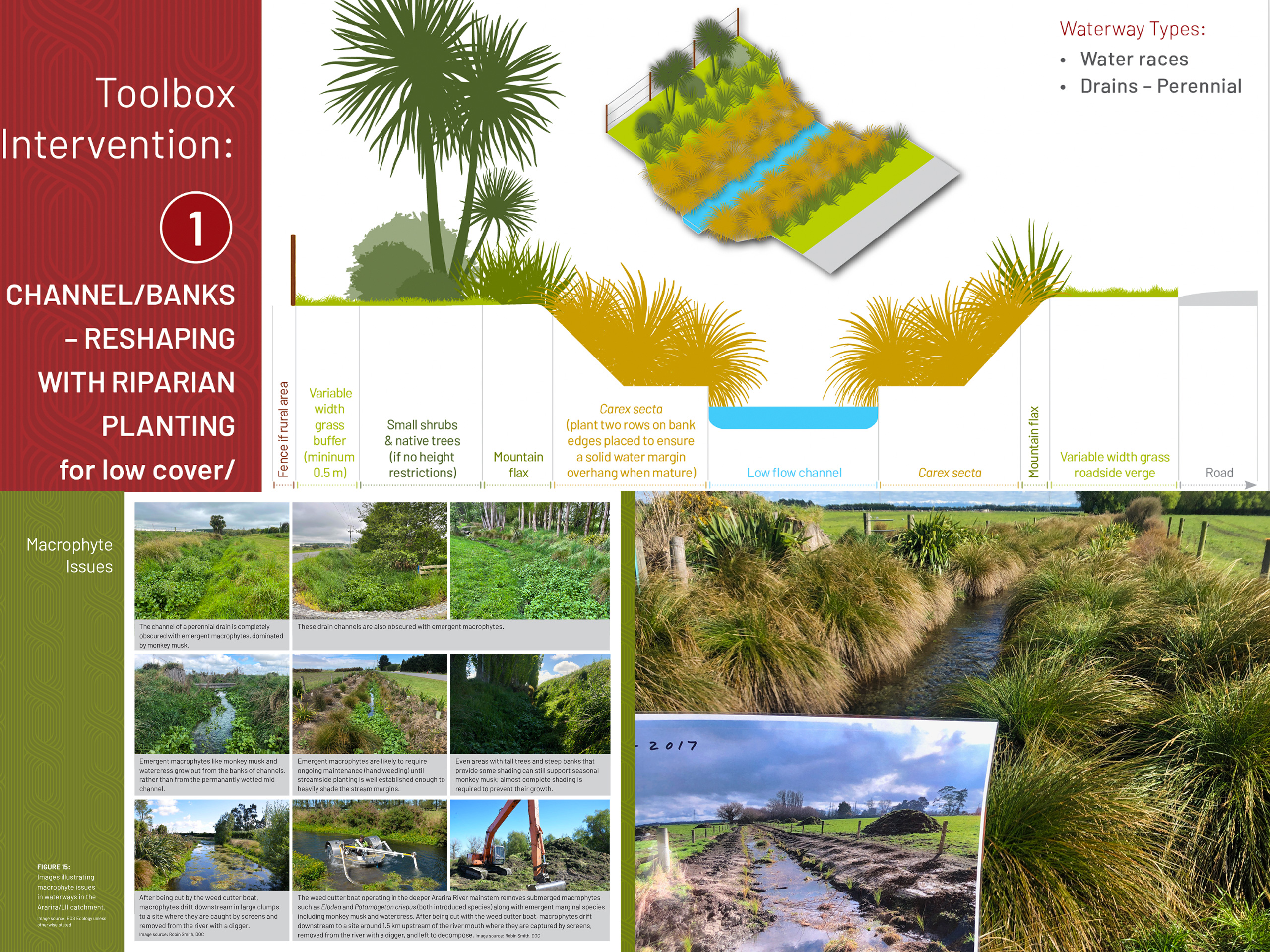
EOS Ecology led the CMP component of the project, characterising the current ecological state and pressures, surfacing the catchment’s core challenges (excessive fine sediment, abundant macrophytes, no space for channel improvements, farmland flooding), and developing the response in genuine co-design with the Project Team. Our GIS team built a new spatial framework using LiDAR-derived elevation models, interrogating twenty existing GIS layers and ground-truthing the network through field surveys (flow permanence, channel condition, eDNA and macroinvertebrates) to replace layers that significantly under-represented the actual drainage network. The plan paired catchment-scale approaches with a ‘toolbox’ of reach-scale interventions, customised for the catchment’s ephemeral, intermittent and perennial waterway types – delivered as a highly visual public document with a ‘blueprint for change’ diagram capturing the key steps. We also provided support to Aqualinc Research and Sustainability Solutions in the development of the IG, which provides a framework to collectively support change and direct implementation of the CMP.
The beautifully presented CMP and IG was delivered to SDC Councillors in August 2022, met with strong support, and was officially handed over to SDC in June 2023 along with our 27-page Summary. The pilot proved the model: SDC subsequently commissioned EOS Ecology and Aqualinc Research to apply the same approach to the six remaining rated catchments in the district, with the Ararira/LII work now cited as a reference example within the wider Living Water programme.
Osbornes Drain Catchment Management Plan
The second CMP in the Selwyn District programme after the Ararira/LII pilot – built around a defining technical reality unique to Osbornes: every drop of water leaves this 1,780 ha catchment via a pump station discharging to Te Waihora/Lake Ellesmere.
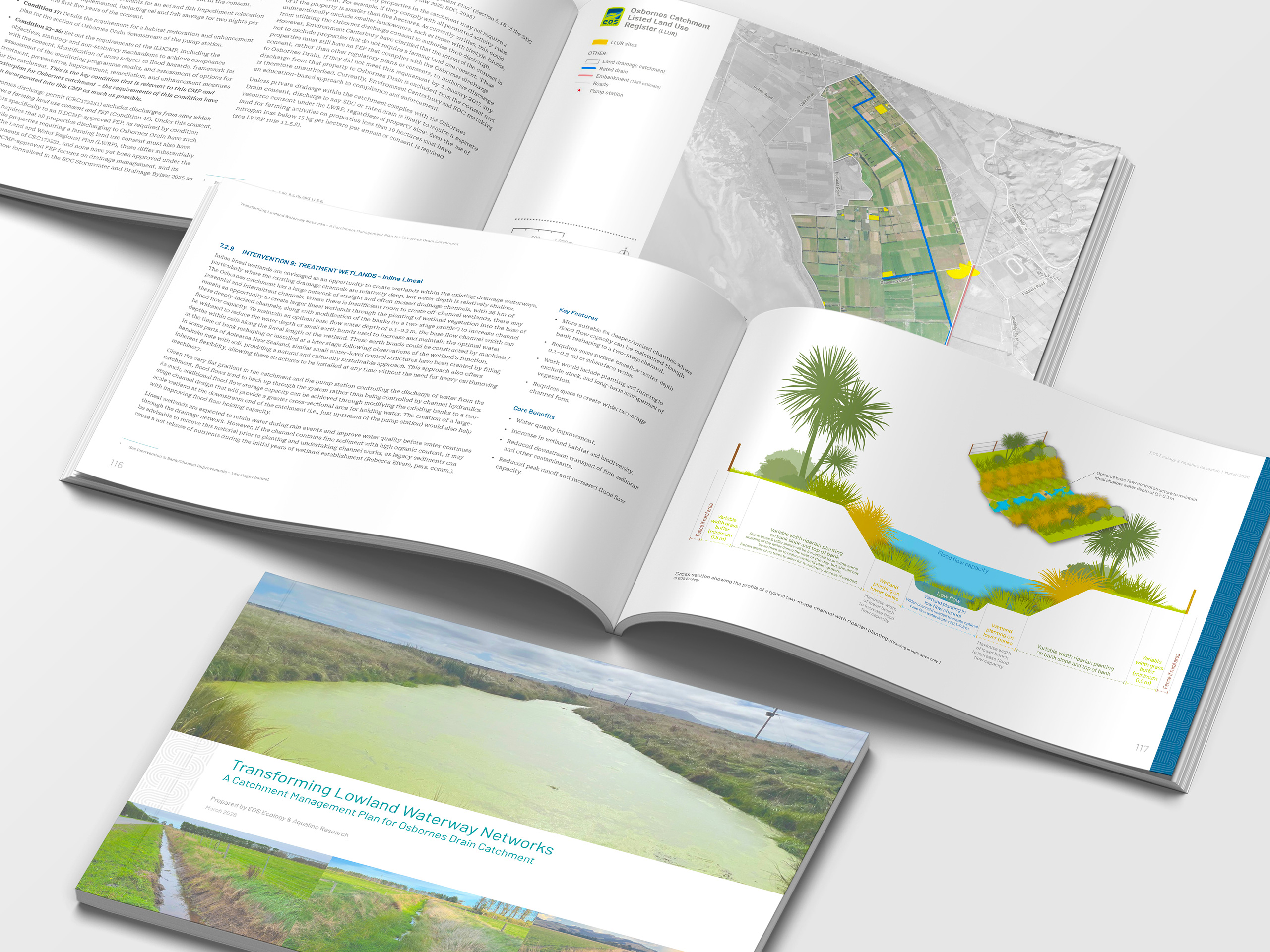
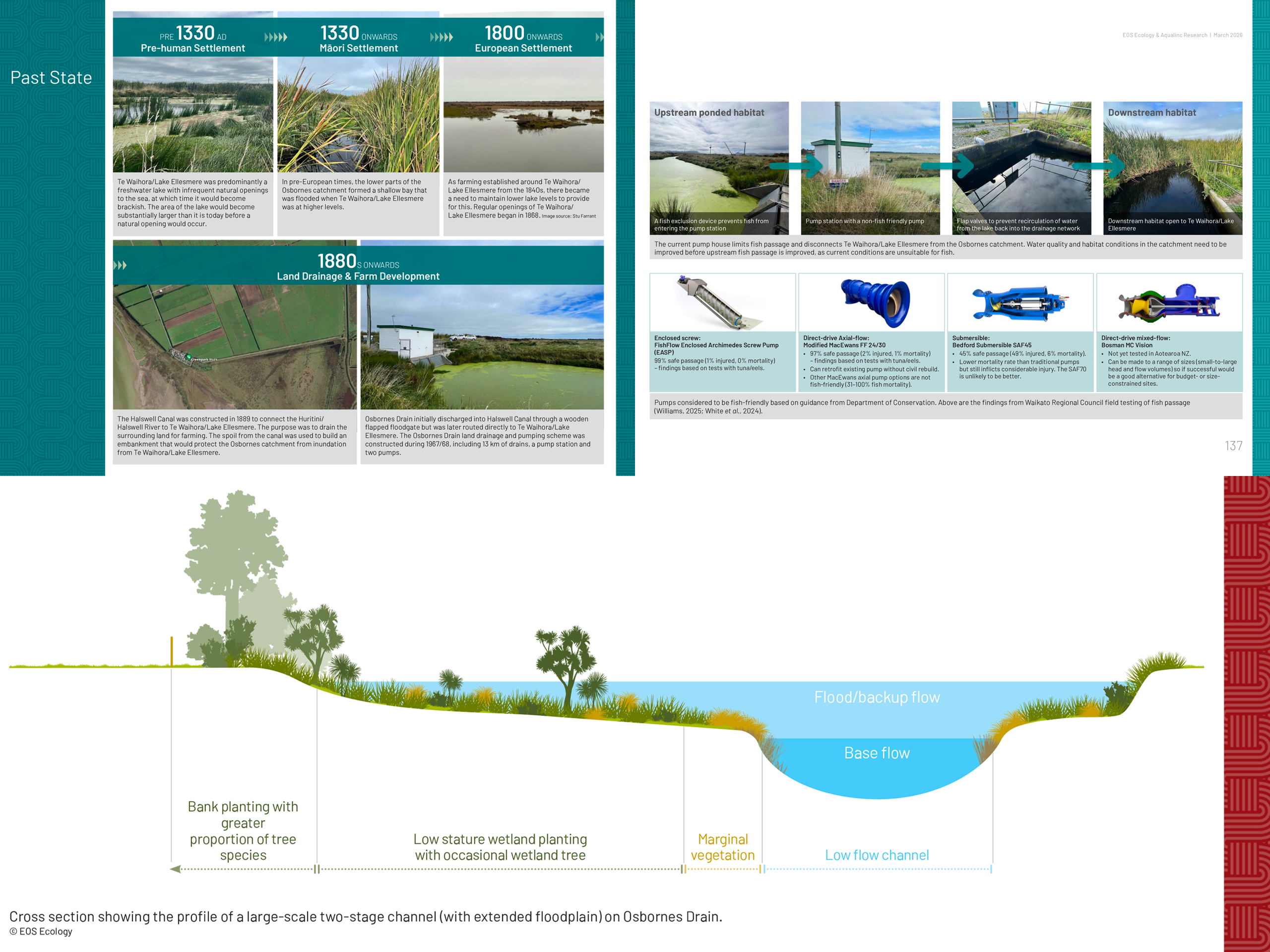
Osbornes Drain catchment is a 1,780 ha rural drainage scheme on the western shore of Te Waihora/Lake Ellesmere – flat, dominated by poorly drained gley soils, salt-enriched from its former life as a shallow brackish bay, and underlain by a continuous aquitard that leaves it with no recorded springs and minimal groundwater input. What makes Osbornes distinctive is its outlet: every drop of water leaves via a pump station, through a Halswell Canal embankment that has stood since 1889. EOS Ecology and Aqualinc Research were commissioned by Selwyn District Council (SDC) to develop the catchment’s first Catchment Management Plan (CMP) – and the second in the SDC programme after Ararira/LII. The plan was co-designed with the Osbornes Drain Catchment Management Working Party (Te Taumutu Rūnanga, Te Rūnanga o Ngāi Tahu, DOC, the Osbornes Land Drainage Committee, Environment Canterbury, and SDC) and sits within the wider Whakaora Te Waihora Co-Governance Agreement.
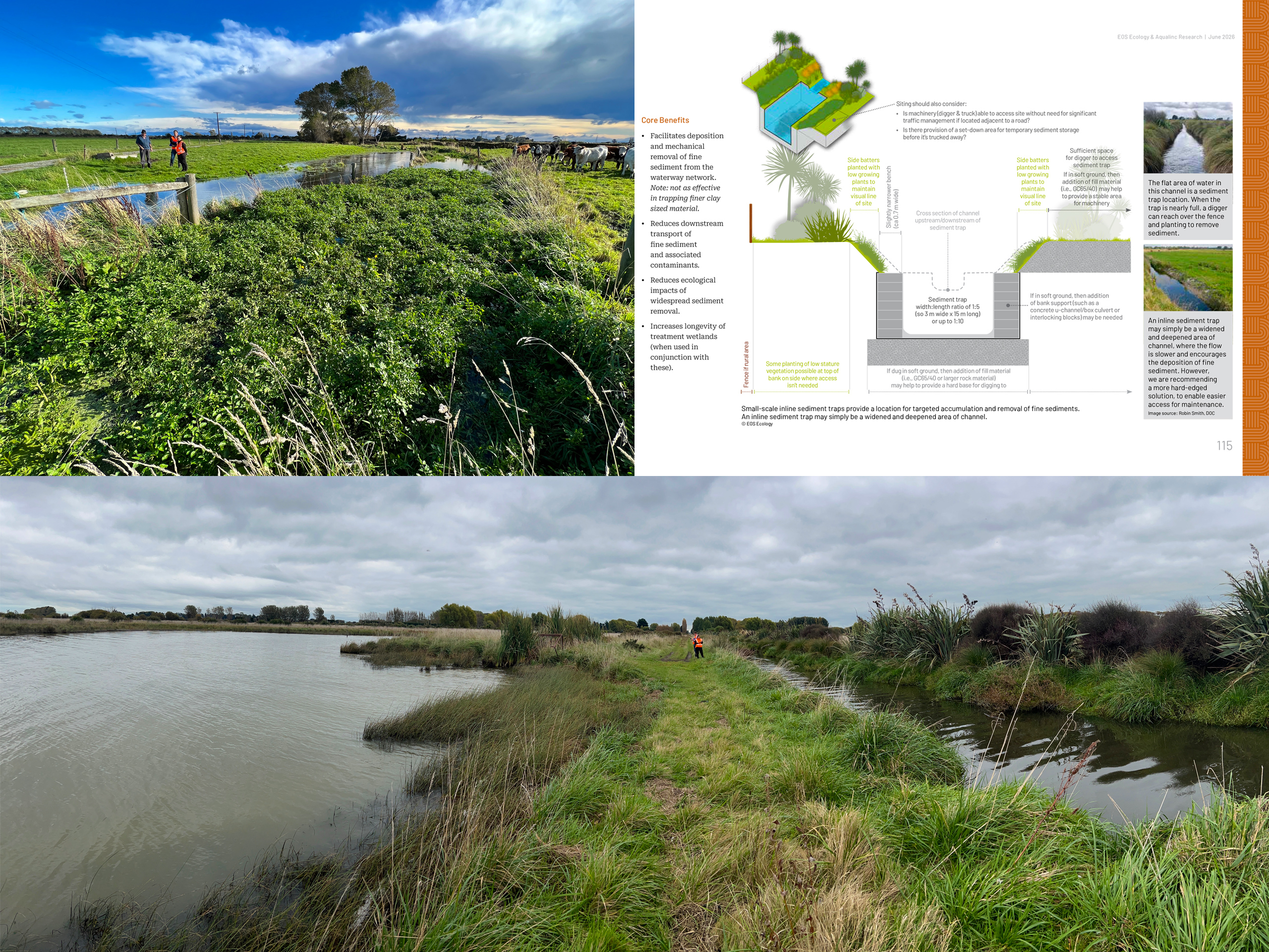
Authored by EOS Ecology with Aqualinc Research, the plan draws on eDNA and macroinvertebrate sampling, electrofishing and historic fish records, a five-year synthesis of SDC water quality monitoring, and a new LiDAR-derived waterway layer built and ground-truthed by our GIS team that lifted the mapped drainage network from 48 km to 95 km, with a further 75.5 km of informal overland flow paths that had never previously been captured. Following our specialised catchment planning approach, we first described the past and present ecological state of the system, and identified the unique challenges faced by the system and those that live in the catchment. These factors then drove our identification of key solutions designed to meet the needs of the catchment and improve its water quality discharge to the quality intended under the catchment’s consent.
The CMP responds with four catchment-scale approaches and a toolbox of 20 reach-scale interventions; ranging from bank and channel improvements, sediment trapping and management, constructed wetlands, and a mix of other interventions designed to deal with the unique nature of the catchment; the only one in Canterbury to have an intermittently pumped discharge. Designed by our science interpreters, the final layout defies its hefty 146 page size, pulling together all the previously disparate knowledge of the catchment and recommended tools and solutions, into a beautifully presented and easy to read document. Together, the plan gives SDC and the Osbornes Land Drainage Committee a defensible, plan-ready framework for managing one of the Te Waihora catchment’s most operationally unusual schemes, and a co-designed pathway for moving from inherited drainage practice toward outcomes that meet the ecological visions of the Working Party can stand behind.
Wairiri Valley Catchment Management Plan
The third CMP in the Selwyn District programme – a foothill, gravity-fed scheme where the central challenge is the influence from a much larger surrounding hill catchment, and a choked downstream that causes floodwaters to back up into the rated catchment.
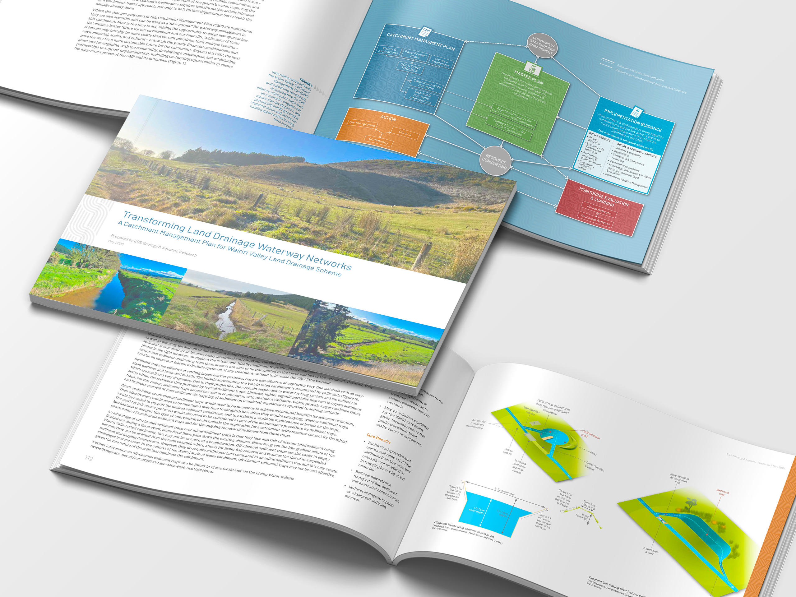
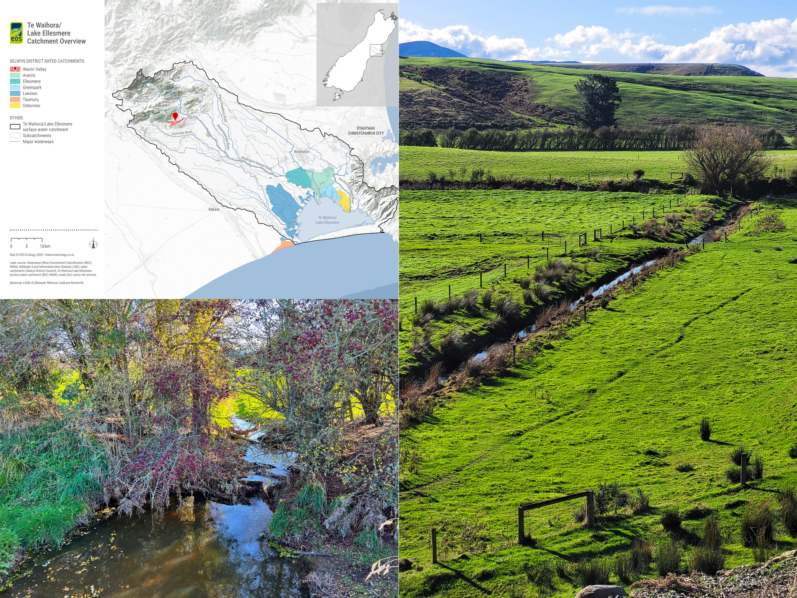
The Wairiri Valley Land Drainage Scheme sits where the Canterbury Plains meet the Southern Alps foothills, around 300 m above sea level west of Glentunnel and Whitecliffs – draining via Wairiri Stream as an upper-plains tributary of the Waikirikiri/Selwyn River. EOS Ecology and Aqualinc Research were commissioned by Selwyn District Council (SDC) to develop the catchment’s first Catchment Management Plan (CMP) – the third in the SDC programme after Ararira/LII and Osbornes. Unlike its lowland predecessors, Wairiri Valley is foothill country: a 377 ha rated scheme of gley-soil valley floor embedded in a 2,757 ha wider catchment of pallic/loess soil mantled foothills.
Authored by EOS Ecology with Aqualinc Research, the plan diagnoses a very different problem from the lowland schemes. The rated catchment sits in gley soils in a relatively small and flat valley floor, surrounded by foothills that are cloaked in highly dispersive pallic soils, and with a largely overgrown channel downstream of the rated area causing flood waters to back up into the rated catchment. Our new LiDAR-derived waterway layer greatly improved the accuracy of the rated network, lifting it from 14 km to 39 km of channels, with a further 126 km of informal overland flow paths inside the rated catchment, and 870 km at the wider catchment scale. Along with eDNA surveys to fill out the knowledge gap for the fish and invertebrate community of the valley’s waterways, this improved technical knowledge was a driving force behind being able to produce a useful and relevant CMP.
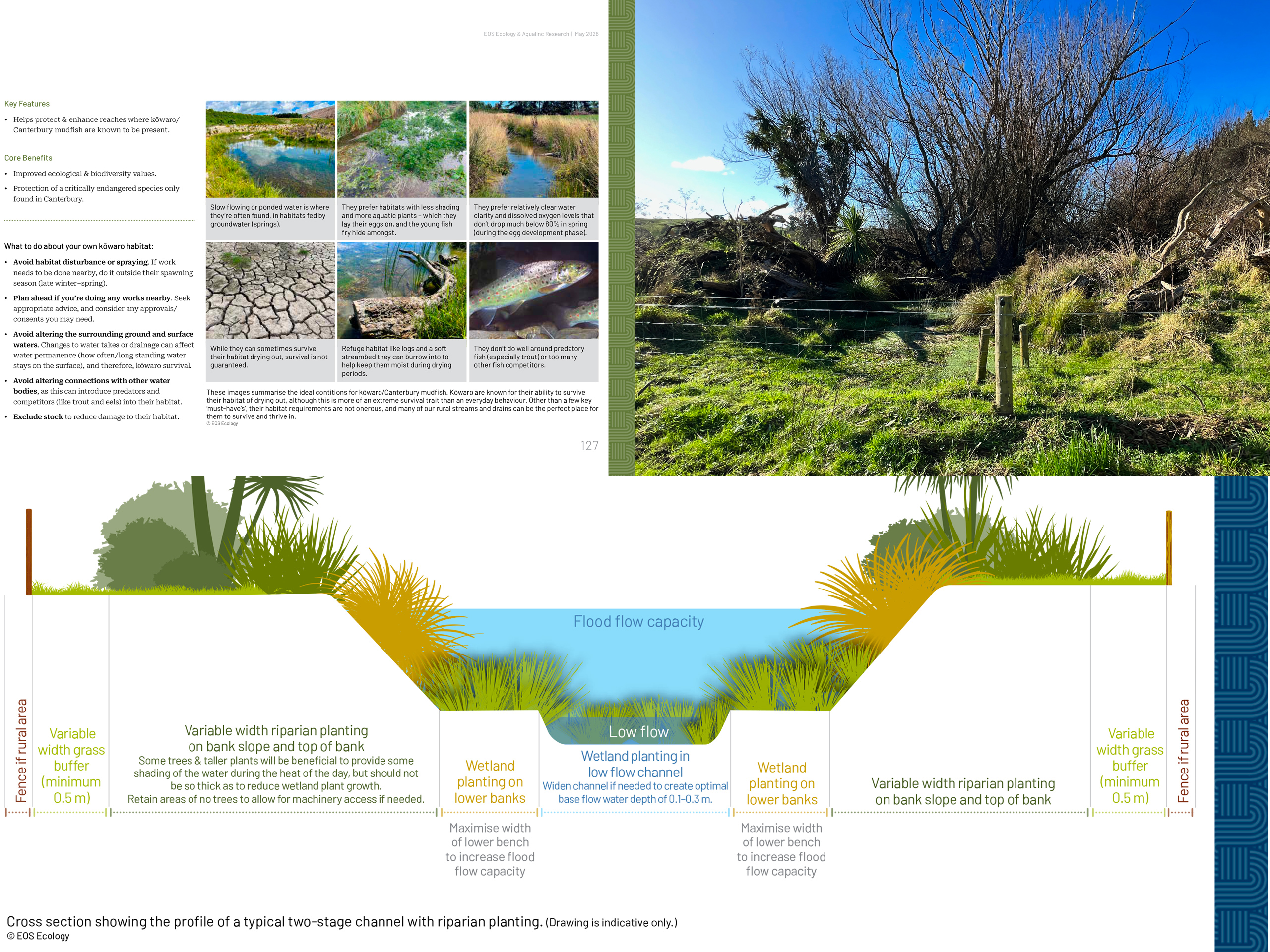
The plan responds with catchment-scale approaches tailored to the foothill setting: transformative practice through Farm Environment Plans (including a templated FEP for the very small landholders); recommendations for how to facilitate support from the wider catchment for the rated area; smart drainage monitoring; and a phased shift away from blanket mechanical sediment removal. Reach-scale tools are not limited to the rated catchment, but provide guidance and support for the entire catchment, focusing on different types of sediment traps based on flow type, and a range of two-stage channels, constructed wetlands and detention basins for improved water treatment and flood management, as well as management of habitat for the Nationally Critical kōwaro/Canterbury mudfish, erosion control for the pallic hill country, and a management approach for the downstream section to alleviate floodwater backup. Designed to be part of a recognised set of Selwyn District CMP documents, our final layout defies its hefty 133 page size, presenting the catchment picture and recommended tools and solutions in a beautifully presented and easy to read document. The plan works in conjunction with the Implementation Guide first developed for the Ararira/LII pilot, with implementation staged through SDC’s planned consenting for routine maintenance and discharge across the six schemes that share that pathway.
Combined Te Waihora Catchment Management Plan
A single CMP covering four lake-edge land drainage schemes – completing the Selwyn District programme with a combined plan that takes catchment-scale thinking to the scale of the whole Te Waihora margin.
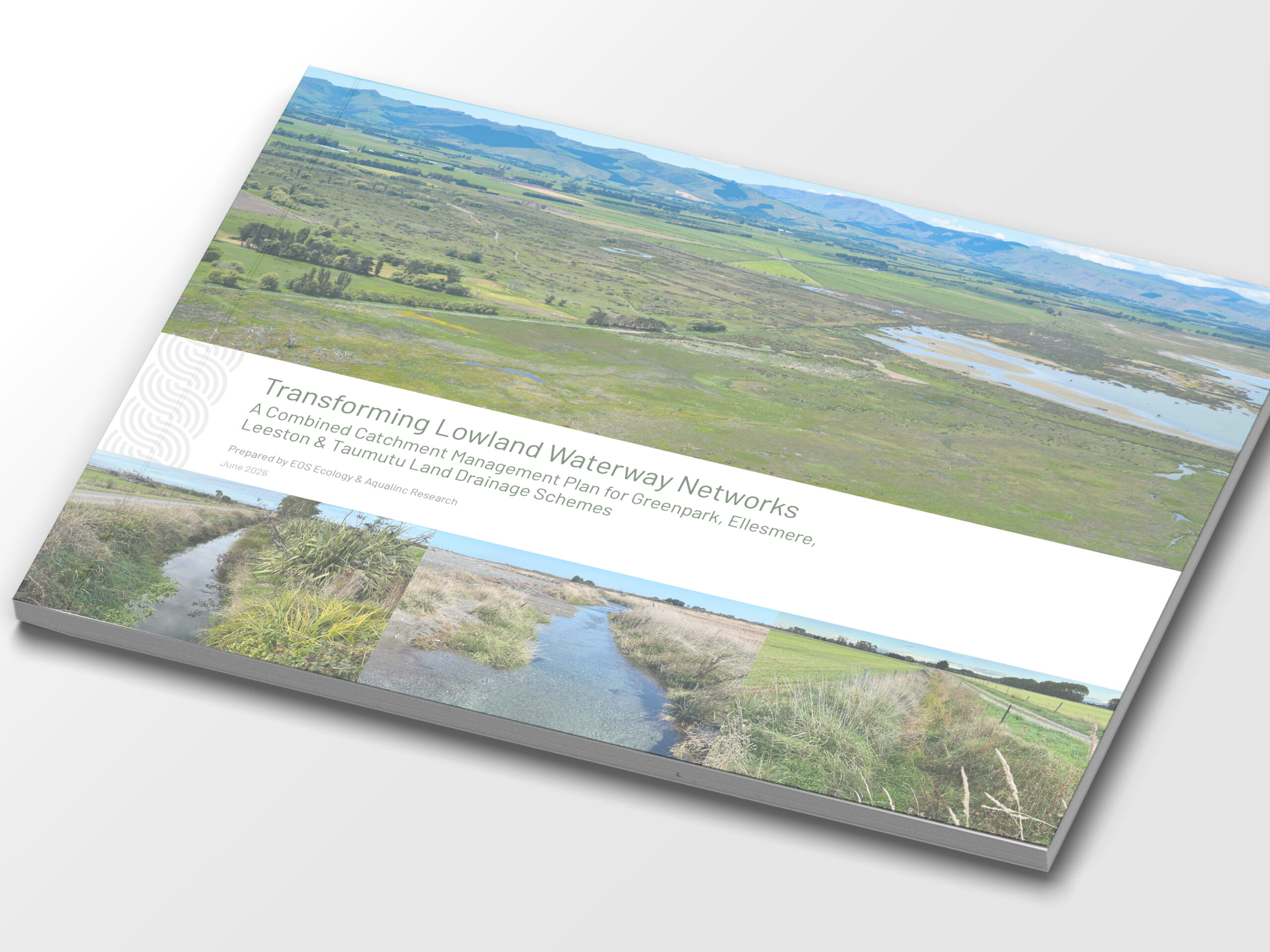
The Combined Te Waihora CMP is the fourth and largest plan in Selwyn District Council’s (SDC) seven-catchment programme – a single document covering four neighbouring lake-edge drainage schemes: Greenpark (2,243 ha), Ellesmere (3,550 ha), Leeston (10,749 ha), and Taumutu (986 ha), totalling 17,528 ha around the margin of Te Waihora/Lake Ellesmere. The plan treats them together to provide the obvious efficiencies of scale for SDC and the Te Komiti Waiora District Land Drainage and Waterway Committee.
Authored by EOS Ecology with Aqualinc Research, the plan diagnoses four catchments that share a context but differ markedly in detail. Greenpark overlain by a continuous aquitard and no recorded springs; Ellesmere with a mix of natural and formed springfed channels; Leeston with 200+ km of rated drains and the only catchment to have an urban area and with known populations of the Nationally Critical kōwaro/Canterbury mudfish; and Taumutu that discharges directly to the coast through piped culverts driven through the gravel shoreline. A new LiDAR-derived waterway layer, built and ground-truthed by our science and GIS teams, re-mapped the combined channel network from 270 km of rated drains to 529 km of total channels, with a further 1,371 km of informal overland flow paths.
Across the four catchments the plan responds with five catchment-scale approaches and a 24-tool reach-scale toolbox built around the lake-edge reality. The tools build on those developed as part of the previous three CMPs for SDC’s other rated catchments with a few tools unique to this CMP: larger-scale two stage channels to manage deeply incised sections; waterway naturalisation and re-meandering of historically straightened natural waterways; a flood-detention basin for the urbanising Leeston township; īnanga spawning habitat restoration in lake-proximal Taumutu and Leeston; and the deliberately counter-intuitive protection of kōwaro habitat through fish-passage barriers that exclude trout. The strategic land-use proposal includes a continuous lake-edge protected landscape from Greenpark through to Leeston, which is realisable as most of the margin is already reserve or conservation land. Sea-level rise sits behind the whole plan as a load-bearing constraint, with the June/July 2013 flood and 2050 inundation overlays used to frame future risk. With four catchments to cover, effective science communication and design of the document was critical to providing a well presented and easy to read output, recognisable as part of the wider set of CMP documents that we have developed for the Selwyn District. Implementation will be staged through the Implementation Guide first developed for the Ararira/LII pilot, completing the seven-catchment programme.
Focus Catchment Map Series
A nationwide map-based state-of-catchment resource – 52 publications across eight regions and 3.7 million hectares – developed by EOS Ecology as the National Science and Technical Lead for the Wai Connection – Tatai Ki Te Wai programme.
The Focus Catchment Map Series (FCMS) was developed by EOS Ecology as part of our role as the National Science and Technical Lead for Wai Connection – Tatai Ki Te Wai, a Ministry for the Environment-funded catchment-group support programme run by Mountains to Sea Conservation Trust. The FCMS is the science backbone of that programme: a map-based state-of-catchment resource that compiles data from more than 150 national, regional, and local sources into 90+ page publications covering six focus areas – parent catchment overview, factors affecting catchment processes, land management, water quality, ecological data, and connection to the coast.
We piloted the FCMS template with the Hakataramea Sustainability Collective, in close consultation with Environment Canterbury to ensure it complemented, rather than duplicated, regional council outputs such as the Catchment Context, Challenges & Values mapping for Freshwater Farm Plans. Our GIS and science teams built the data workbenches to source, standardise, quality-check and analyse the underlying datasets (land cover, climate, geology, topography, protected areas, threatened environments, soils, modelled sediment yield, and site-specific monitoring of water quality, macroinvertebrates, and fish). Our science communicators and designers then turned that material into 30+ maps and 50+ tables per publication, with the plain-English commentary that lets non-technical end users navigate it confidently.
Between Jan 2024–Jun 2025 we produced 52 FCMS publications across eight regions, covering 3.7 million hectares, processing over 2.8 million raw monitoring data points, mapping and analysing data from more than 9,000 sites, and running 47 in-person science workshops to take catchment groups through their FCMS. Feedback from project operators, catchment groups, councils, and iwi has been resoundingly positive, with Environment Canterbury describing the FCMS as taking ‘a large quantity of information and present[ing] it in an easy to access, visually appealing and scientifically accurate way’. Built on a consistent national methodology, the FCMS lets groups compare their catchment with others and ties their local picture back to the national- and regional-scale datasets used in plans and management strategies. With the ‘Wai Connection’ programme now complete, the framework is now available for any organisation across Aotearoa New Zealand to commission their own focus catchment map series.


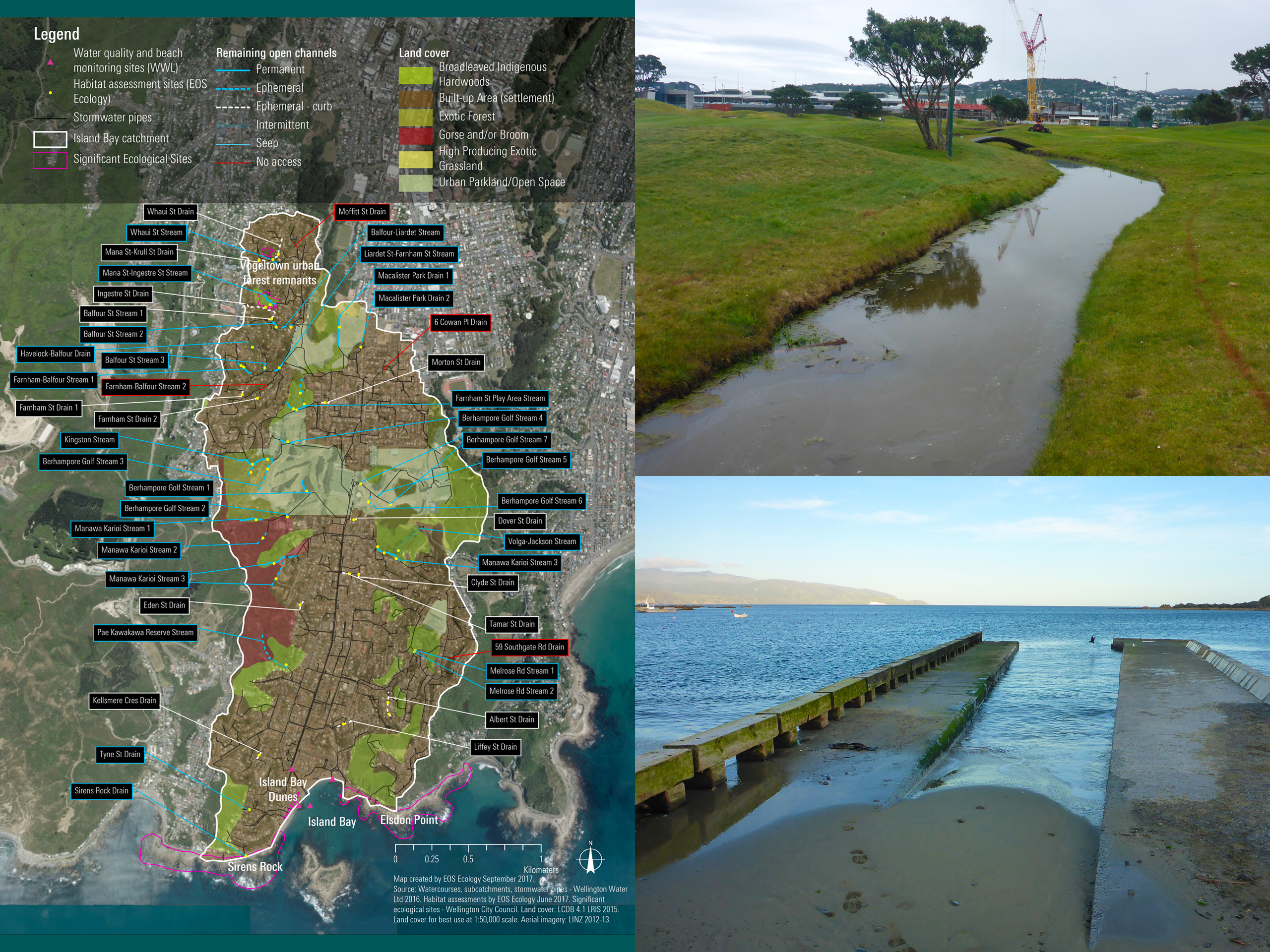
Wellington Water ICMP Ecological Assessments
Stage-2 ecological assessments of five Wellington urban catchments – locating the city's surviving open watercourses, mapping their ecological values, and identifying the data gaps and management priorities that need attention as Wellington Water's Integrated Catchment Management Plans evolve.
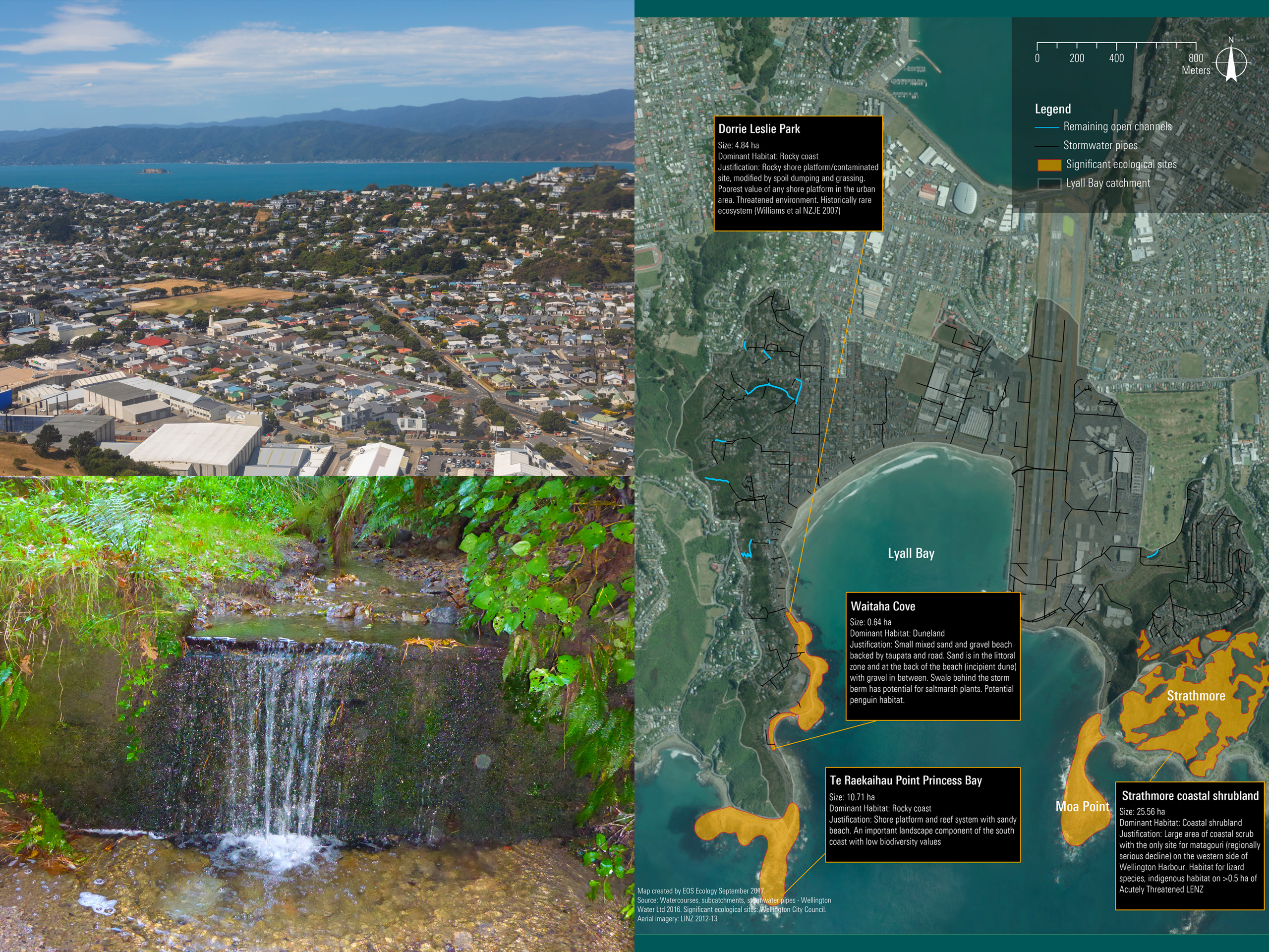
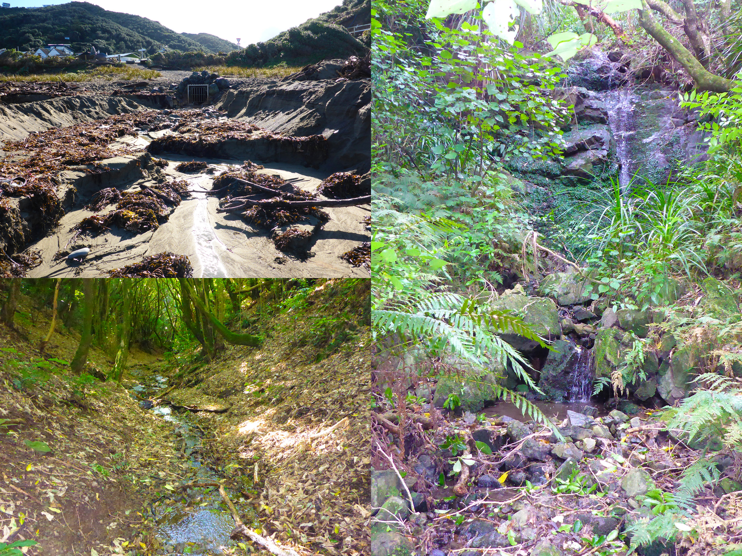
Wellington’s natural watercourses have been so heavily modified by urbanisation that most now run through pipes. Wellington Water Limited (WWL) commissioned EOS Ecology to deliver high-level Stage-2 ecological assessments for five of its Integrated Catchment Management Plan (ICMP) catchments between 2016 and 2018: Lambton Harbour, Evans Bay, the South-east Coast catchment, Island Bay-Houghton Bay, and Lyall Bay. Together these assessments cover hundreds of remnant open-channel sections across more than 160 separate watercourses, many of them effectively hidden from public and regulatory awareness despite still supporting freshwater biota.
Each assessment was deliberately scoped as a desk-based exercise informed by existing data, local experts, and site visits – no new ecological sampling was undertaken – producing for each catchment a description of the surviving watercourses, a preliminary amenity-value assessment of the remnant open channels, and a summary of the relevant marine receiving environment. The findings tell a consistent Wellington story: most of the original stream length has been piped; the small number of permanently flowing surface streams that remain often punch above their weight ecologically; and accumulation of stormwater contaminants in harbour sediments influenced by catchment exposure.
Each report flagged critical knowledge gaps that would otherwise impede robust ICMP decision-making and identified opportunities for enhancing natural values where stormwater management overlapped with stream ecology. Recommendations consistently included remediation of fish migration barriers in open and piped sections, increasing instream habitat complexity, ecological enhancement of reserve riparian zones, and broad adoption of Water Sensitive Urban Design approaches. The five reports collectively gave WWL the ecological baseline it needed to take each catchment through the next stages of ICMP development.
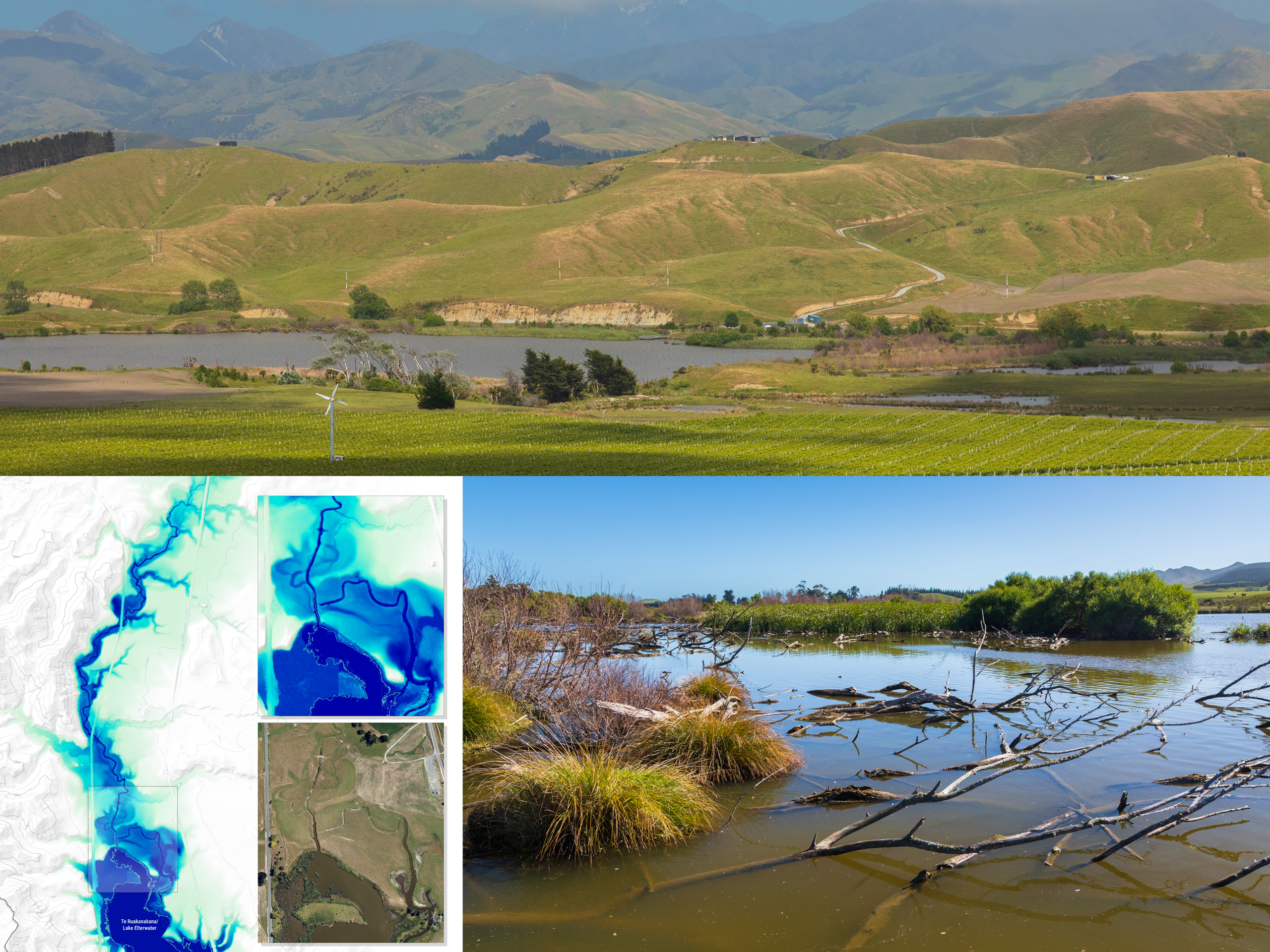
Te Ruakanakana/Lake Elterwater Catchment Sediment Management
Advanced LiDAR-based spatial analysis to identify sediment and sediment-derived nutrient sources in a data-limited Marlborough catchment – turning gaps in conventional water quality monitoring into a quantified, spatially explicit roadmap for landowner-led restoration.
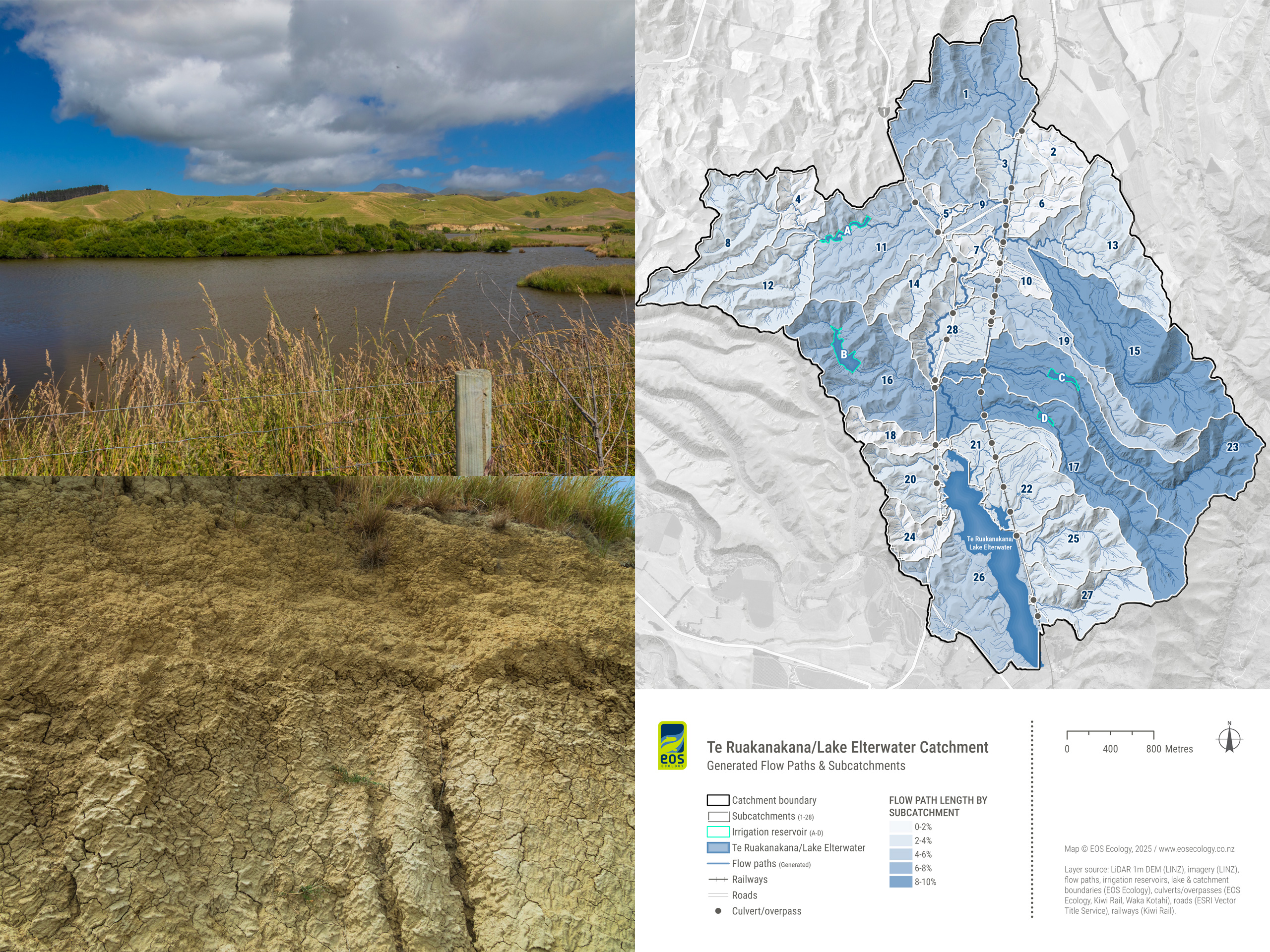
Te Ruakanakana/Lake Elterwater is a shallow, intermittent lake (53–73 ha) in the 1,607 ha Te Ruakanakana subcatchment of the Flaxbourne River in eastern Marlborough, a landscape dominated by highly erodible pallic soils that disperse easily and are difficult to settle once suspended in water. The lake is hyper-eutrophic and has dried out four times between 2000–2020. EOS Ecology was commissioned by the Lake Elterwater Restoration Group, with funding through the Access 2 Experts (A2E) programme, to identify the primary sources of sediment and sediment-derived nutrients from the wider catchment that were affecting the lake as the foundation for a future Catchment Management Plan. With contributing waterways all intermittently flowing, the traditional use of water quality data to identify key source areas was not possible, and the existing modelled data was too coarse to be of use – so we designed a spatially informed analysis programme to map catchment risk. The work was undertaken in close collaboration with the Group’s technical specialist from WetlandsNZ, with NZ Landcare Trust facilitating landowner engagement.
Our June 2025 report combined knowledge gained from a site visit and landowner conversations with high-resolution LiDAR-derived digital elevation models and aerial imagery to build a suite of bespoke geospatial layers – fine-resolution slope, land cover class based on high resolution RGB imagery and refined via over 200 test runs, overland flow paths, waterway lines, watersheds, and subcatchment boundaries adjusted for the moderating influence of the catchment’s four large irrigation reservoirs. A relative elevation model derived from LiDAR, alongside digitised topographic maps from 1939–2019, allowed us to detect paleochannels and historical lake-edge geometry that further informed the analysis. The work delineated 28 subcatchments and 324.8 km of flow paths (over a tenfold increase on previously available data), and produced a reservoir-aware erosion-risk matrix that rated subcatchments on a multi-scale risk matrix. The methodology was deliberately designed to be replicable across other data-limited catchments.
Following the subcatchment risk ranking, the report sets out a suite of targeted mitigation options developed alongside the landowner site visits, maximising the sediment and nutrient retention function of the four large irrigation reservoirs through rāupo plantings and lineal seepage wetlands downstream, retrofitting small-scale sediment traps and planted micro-wetlands at existing choke points, and restoring a meandering channel and head-of-lake wetland that would add at least 650 m of channel. Targeted cut-face erosion control options draws directly on EOS Ecology’s own Port Hills Christchurch trials. We also designed a three-tier event-based water quality monitoring framework anchored on a primary site and supplementary sites, and built around telemetered autosamplers to capture storm-driven pulses that mobilise pallic soils in otherwise intermittently flowing waterways. Together, these outputs give the restoration group and the landowners on the ground a scientifically robust, spatially explicit roadmap for prioritising interventions and building out a Catchment Management Plan.